Search Results Header
Search Results
Notice: Access to some items may be restricted because of copyright. Members of the Columbia Community can log in and learn about the Terms of Use.
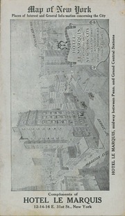
81. Map of New York : places of interest and general information concerning the city
- Collection Name: Seymour B. Durst Old York Library Collection
- Date: [1920?]

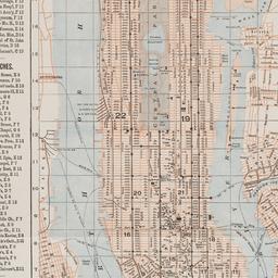
82. Map of New York : places of interest and general information concerning the city
Ohman Map Co
- Name: Ohman Map Co
- Collection Name: Seymour B. Durst Old York Library Collection
- Date: c1913

83. Map of New York and vicinity
Dripps, M
- Name: Dripps, M
- Collection Name: Seymour B. Durst Old York Library Collection
- Date: c1865
84. Map of New York City
Fisk, E. F
- Collection Name: Seymour B. Durst Old York Library Collection
- Date: c1891
- Item in Context: https://dlc.library.columbia.edu/durst/cul:cc2fqz613s
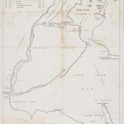
85. [Map of New York Harbor, New York Bay, and Staten Island]
Pease, Richard H., 1813-1869
- Collection Name: Seymour B. Durst Old York Library Collection
- Date: 18--?]
- Item in Context: https://dlc.library.columbia.edu/durst/cul:bk3j9kd52h
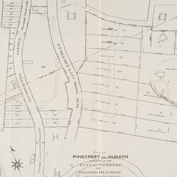
86. Map of Pinecrest-on-Hudson situated in the City of Yonkers and Village of Hastings Westchester Co
- Collection Name: Seymour B. Durst Old York Library Collection
- Date: 1907]
- Item in Context: https://dlc.library.columbia.edu/durst/cul:gtht76hdsx
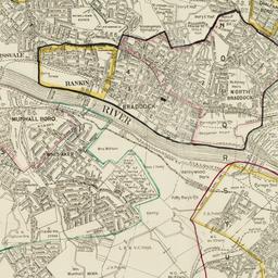
87. Map of Pittsburgh area, showing locations of the Carnegie Steel Mills
Carnegie Corporation of New York
- Collection Name: Carnegie Corporation of New York Records. Series III. Grants. III.A. Grant files, ca.1911-1988. Box no. 60
- Date: 1917
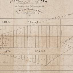
88. Map of property at Harlaem [sic] to be sold in one parcel on Tuesday the 3rd of February 1835 by James Bleecker & Sons at 11 o'clock
James Bleecker & Sons
- Collection Name: Seymour B. Durst Old York Library Collection
- Date: [1835]
- Item in Context: https://dlc.library.columbia.edu/durst/cul:d2547d7wnd
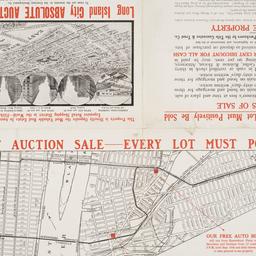
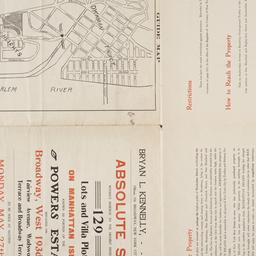
89. Map of property belonging to the Courtney Development Company situate partly in the First and Second Wards, borough of Queens, city of New York
Browne, Walter I
- Collection Name: Seymour B. Durst Old York Library Collection
- Date: 1913]
- Item in Context: https://dlc.library.columbia.edu/durst/cul:8kprr4xgzp
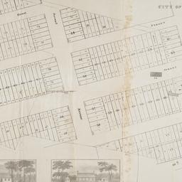
90. Map of Prospect Hill late the seat of Francis B. Winthrop, Esqr., in the Twelfth Ward in the city of New York
- Collection Name: Seymour B. Durst Old York Library Collection
- Date: [1879?]
- Item in Context: https://dlc.library.columbia.edu/durst/cul:95x69p8d0j
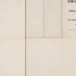
91. Map of Stratton Bluffs at College Point on Flushing Bay, New York
Roullier, G. A
- Collection Name: Seymour B. Durst Old York Library Collection
- Date: [1891]
- Item in Context: https://dlc.library.columbia.edu/durst/cul:z34tmpg4hd
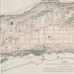
92. Map of that part of the city of New York north of 155th street : showing the progress made in laying out streets, roads, public squares and places, by the Commissioners of the Central Park, under Chap. 565 of Laws of 1865 and of new Pier and Bulkhead Laws under Chap. 697 of Laws of 1867
Major & Knapp Engraving, Manufacturing & Lithographic Co
- Collection Name: Seymour B. Durst Old York Library Collection
- Date: 1870
- Item in Context: https://dlc.library.columbia.edu/durst/cul:70rxwdbrw9
93. [Map of the area bounded by Broadway and St. Nicholas from West 190th Street to West 193rd Street]
- Collection Name: Seymour B. Durst Old York Library Collection
- Date: [1907]
- Item in Context: https://dlc.library.columbia.edu/durst/cul:m905qfttgq
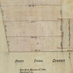
94. [Map of the area bounded by Forty Third Street and Broadway]
Ammerman & Ford (Firm)
- Collection Name: Seymour B. Durst Old York Library Collection
- Date: 1880
- Item in Context: https://dlc.library.columbia.edu/durst/cul:15dv41ns2k
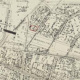
95. [Map of the area bounded by New Chambers Street, Peart Street, Beekman Street, and Nassau Street]
- Collection Name: Seymour B. Durst Old York Library Collection
- Date: 1914?]
- Item in Context: https://dlc.library.columbia.edu/durst/cul:4mw6m905r9
96. [Map of the area in Long Island City from Vernon Ave. to Meadow St. between Sixth St. and Fourteenth St.]
Ohman, August R
- Collection Name: Seymour B. Durst Old York Library Collection
- Date: [1908]
- Item in Context: https://dlc.library.columbia.edu/durst/cul:s4mw6m907v
97. [Map of the area in Lower Manhattan bound by Pine Street, South Street, Wall Street and Front Street]
- Collection Name: Seymour B. Durst Old York Library Collection
- Date: 1895?]
- Item in Context: https://dlc.library.columbia.edu/durst/cul:4mw6m905rb

98. Map of the bays, harbors, and rivers around New York : showing the channels, soundings, lighthouses, buoys &c., and the complete topography of the surrounding country : including Hempstead, Sandy-Hook, South-Amboy, Newark, Yonkers, N. Rochelle & Glen Cove
Bache, A. D. 1806-1867
- Name: Bache, A. D. 1806-1867
- Collection Name: Seymour B. Durst Old York Library Collection
- Date: [1866]
- Item in Context: https://dlc.library.columbia.edu/durst/cul:wpzgmsbcfh
99. Map of the boundaries of the Fire Department of the City of New York
New York (N.Y.). Fire Department
- Name: New York (N.Y.). Fire Department
- Collection Name: Seymour B. Durst Old York Library Collection
- Date: 1871
- Item in Context: https://dlc.library.columbia.edu/durst/cul:98sf7m0chc

100. Map of the Central Park : showing the progress of the work up to January 1st 1860
Olmsted, Frederick Law, 1822-1903
- Collection Name: Seymour B. Durst Old York Library Collection
- Date: [1860]
- Item in Context: https://dlc.library.columbia.edu/durst/cul:15dv41ns2m