Search Results Header
Search Constraints
Showing results for: %22Harbors New York Region Maps%22 Remove constraint %22Harbors New York Region Maps%22Search Results

1. Map 22 : residential development plan 1985
maps
- Published: s.n: United States. c1985]
- Format: maps
- Catalog Record: check availability

2. Regional plan
books
- Published: Regional Plan of New York and Its Environs: New York. 1929-1931
- Format: books
- Catalog Record: check availability
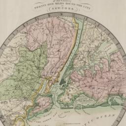
3. Map of the country twenty-five miles round the city of New-York
Burr, David H., 1803-1875
maps
- Name: Burr, David H., 1803-1875
- Published: David H. Burr: New York. 1831
- Format: maps
- Online: click here for full-text
- Catalog Record: check availability
4. Brooklyn bus map
New York City Transit Authority
maps
- Name: New York City Transit Authority
- Published: New York City Transit Authority: Brooklyn. c1994
- Format: maps
- Catalog Record: check availability
5. New York, the politics of urban regional development
Danielson, Michael N
books
- Name: Danielson, Michael N
- Published: Published for the Institute of Governmental Studies and the Institute of International Studies [by] University of California Press: Berkeley. c1982
- Format: books
- Catalog Record: check availability
6. Downtown Manhattan office building map
Jones, Lang, Wootton
maps
- Name: Jones, Lang, Wootton
- Published: Jones, Lang, Wootton: New York, N.Y. c1991
- Format: maps
- Catalog Record: check availability
7. Queens bus map
New York (State). Metropolitan Transportation Authority
maps
- Name: New York (State). Metropolitan Transportation Authority
- Published: New York City Transit Authority: New York. c1993
- Format: maps
- Catalog Record: check availability
8. Bronx bus map : February 1995
New York City Transit Authority
maps
- Name: New York City Transit Authority
- Published: New York City Transit Authority: Brooklyn, NY. 1995
- Format: maps
- Catalog Record: check availability
9. Manhattan bus map
New York City Transit Authority
maps
- Name: New York City Transit Authority
- Published: New York City Transit Authority: Brooklyn, N.Y. c1995
- Format: maps
- Catalog Record: check availability
10. New York City, Manhattan, Brooklyn, Bronx, Queens & Staten Island map
Rand McNally and Company
maps
- Name: Rand McNally and Company
- Published: Rand McNally & Co: Chicago. [1982?]
- Format: maps
- Catalog Record: check availability
11. Look at America: New York city
books
- Published: Houghton. c1956
- Format: books
- Catalog Record: check availability

12. Maps and diagrams showing present conditions, New York and its environs, March, 1923
Regional Plan of New York and Its Environs
books
- Name: Regional Plan of New York and Its Environs
- Published: Plan of New York and Its Environs: New York. 1923
- Format: books
- Online: click here for full-text
- Catalog Record: check availability
13. The Unsheltered woman : women and housing in the 80s
books
- Published: Center for Urban Policy Research, Rutgers University: New Brunswick, N.J. c1985
- Format: books
- Catalog Record: check availability
14. Map of New York
Trott, E. R
maps
- Name: Trott, E. R
- Published: Eugene R. Trott: New York. [191-?]
- Format: maps
- Catalog Record: check availability
15. Topographical map of New York City, County, and vicinity : showing old farm lines &c
Harrison, J. F
maps
- Name: Harrison, J. F
- Published: M. Dripps: New York. 1853
- Format: maps
- Catalog Record: check availability

16. New York state planning and development regions
New York (State). Office of Planning Coordination
books
- Name: New York (State). Office of Planning Coordination
- Published: New York State Office of Planning Coordination: New York. 1970
- Format: books
- Online: click here for full-text
- Catalog Record: check availability
![[Maps of Manhattan]](https://archive.org/services/img/ldpd_11290413_000)
17. [Maps of Manhattan]
maps
- Published: s.n: New York?. ca. 1890]
- Format: maps
- Online: click here for full-text
- Catalog Record: check availability
18. Taunton new guide map and directory of New York City
Taunton, S. D. L
maps
- Name: Taunton, S. D. L
- Published: S.D.L. Taunton: New York. [1883]
- Format: maps
- Catalog Record: check availability
19. New York, guide touristique et carte
New York Convention and Visitors Bureau, inc
maps
- Name: New York Convention and Visitors Bureau, inc
- Published: New York Convention and Visitors Bureau, Inc: New York, N.Y. [1978]
- Format: maps
- Catalog Record: check availability
20. Topographical map of the cities of New York, Brooklyn, Williamsburgh & Jersey City and the villages of Hoboken, Greenpoint, Astoria
Dripps, M
maps
- Name: Dripps, M
- Published: M. Dripps: New York. 1854
- Format: maps
- Catalog Record: check availability
21. New York City--5 maps in 1 : Manhattan streets, Midtown, Downtown, Greenwich Village, Manhattan subways
Hagstrom Map Company
maps
- Name: Hagstrom Map Company
- Published: Hagstrom Map Co: Maspeth, NY. c1995
- Format: maps
- Catalog Record: check availability
22. Cleartype street, house number, and transportation map of Manhattan (New York County, N.Y.)
American Map Company (New York, N.Y.)
maps
- Name: American Map Company (New York, N.Y.)
- Published: The Company: New York. [ca. 1948]
- Format: maps
- Catalog Record: check availability
23. New-York city & county map : with vicinity entire, Brooklyn, Williamsburgh, Jersey City &c. in the 79th year of the independence of the United States
Magnus, Charles
maps
- Name: Magnus, Charles
- Published: Charles Magnus: New York. [1855?]
- Format: maps
- Online: click here for full-text
- Catalog Record: check availability
24. New-York City guide map showing business parts of Brooklyn, elevated rail roads, horse car and stage lines, hotels, churches, theatres, docks, piers, &c
maps
- Published: [publisher not identified]: New York?. [1884?]
- Format: maps
- Catalog Record: check availability
Search Other Sources for: %22Harbors New York Region Maps%22
Try your search in one of these related resources. (Search results will display in a new window.)
-
Avery Index to Architectural Periodicals
A comprehensive listing of journal articles published worldwide on architecture and design, archaeology, city planning, interior design, landscape architecture, and historic preservation. -
Brooklyn Historical Society Photography Collection
Search for individual photographs. Approximately 5,000 of our images are currently available online, but more images are added regularly. -
Brooklyn Public Library: Historic Brooklyn Photographs
Selection of more than ten thousand historic photographs from the Brooklyn Collection. -
CLIO: Columbia Libraries Catalog
Search for books, articles, journals, online resources and more. -
DLC: Columbia Libraries Digital Collections
A gateway to digital projects and online exhibitions that have been published on the web by Columbia University Libraries/Information Services (CUL/IS). -
Museum of the City of New York
Over 150,000 images and objects from the collections of the Museum of the City of New York.
Note: to come. -
New York Historical Society
Digital images from the library and museum collections. -
NYPL Digital Collections
Provides free and open access to over 800,000 images digitized from the The New York Public Library's vast collections.