Search Results Header
Search Constraints
Showing results for: "Manhattan (New York, N.Y.)" Remove constraint "Manhattan (New York, N.Y.)" Format manuscripts Remove constraint Format: manuscripts Format maps Remove constraint Format: mapsSearch Results

217. Plan of the city of New York in North America : surveyed in the years 1766 & 1767
Ratzer, Bernard
maps
- Name: Ratzer, Bernard
- Published: J.H. Colton: New York. 1853
- Format: maps
- Online: click here for full-text
- Catalog Record: check availability
218. Plan of the city of New York, with the recent and intended improvements
Bridges, William, -1814
maps
- Name: Bridges, William, -1814
- Published: Isaac Riley: New York. 1807
- Format: maps
- Online: click here for full-text
- Catalog Record: check availability
219. A plan of the city of New-York
Holland, Samuel, 1728-1801
maps
- Name: Holland, Samuel, 1728-1801
- Published: D.T. Valentine: New York, N.Y. 1863]
- Format: maps
- Online: click here for full-text
- Catalog Record: check availability
220. A plan of the city of New-York & its environs : to Greenwich, on the North or Hudsons River, and to Crown Point, on the East or Sound River, shewing the several streets, publick buildings, docks, fort & battery, with the true form & course of the commanding grounds, with and without the town
Montrésor, John, 1736-1799
maps
- Name: Montrésor, John, 1736-1799
- Published: Engraved from the original map by John Montresor for D.T. Valentine's Manual for 1855 by G. Hayward: New York, N.Y. [1855]
- Format: maps
- Online: click here for full-text
- Catalog Record: check availability

221. Plan of the island of New York in North America but only from the eastern side in the vicinity of the late Fort Washington, afterward Knyphausen, which was taken in the month of May 1779 from the Laurel HIll, but first drawn in the month of January 1781 in the hut encampment near Fort Knyphausen
maps
- Published: Common Council: New York. 1854]
- Format: maps
- Catalog Record: check availability
222. A plan of the north east environs of the city of New-York
Holland, Samuel, 1728-1801
maps
- Name: Holland, Samuel, 1728-1801
- Published: Engraved for D.T. Valentine's Manual for 1859 by Geo. Hayward: New York, N.Y. [1859]
- Format: maps
- Online: click here for full-text
- Catalog Record: check availability

223. A plan of the north east environs of the city of New-York performed by order of His Excellency the Earl of Loudon & ca. & ca
Holland, Samuel, 1728-1801
maps
- Name: Holland, Samuel, 1728-1801
- Published: George Hayward: New York. [1859]
- Format: maps
- Online: click here for full-text
- Catalog Record: check availability
224. Rand, McNally & Co.'s map of New York City, Brooklyn, Jersey City and vicinity
Rand McNally and Company
maps
- Name: Rand McNally and Company
- Published: Rand, McNally & Co: New York. 1891
- Format: maps
- Catalog Record: check availability
225. Rand, McNally & Co.'s map of New York City, Brooklyn, Jersey City and vicinity
Rand McNally and Company
maps
- Name: Rand McNally and Company
- Published: Rand McNally & Co: Chicago. 1889, c1888
- Format: maps
- Catalog Record: check availability
226. Rapid transit map of greater New York
maps
- Published: General Drafting Co: Convent Station, N.J. [1965?]
- Format: maps
- Catalog Record: check availability
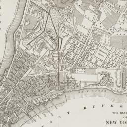
227. The Ratzer map of New York City, 1767
maps
- Published: Longmans, Green & Co: New York?. 18--?]
- Format: maps
- Online: click here for full-text
- Catalog Record: check availability
228. Riverside Park map and guide
Earth Environmental Group
maps
- Name: Earth Environmental Group
- Published: Earth Environmental Group: New York. c1983
- Format: maps
- Catalog Record: check availability
229. Robinson's atlas of the City of New York : Embracing all territory within its corporate limits from official records, private plans & actual surveys
Robinson, E
maps
- Name: Robinson, E
- Published: E. Robinson: New York. 1885
- Format: maps
- Catalog Record: check availability
230. The runner's map of Central Park
Williams, Ron
maps
- Name: Williams, Ron
- Published: New York. c1978
- Format: maps
- Catalog Record: check availability
![[Second Avenue subway]](https://dlc.library.columbia.edu/assets/thumbtack-fa-placeholder-5ad5ec121fe28e3000ec05ad1502d9be955a6f73012ad675de32a7ef0b38b49f.png)
231. [Second Avenue subway]
manuscripts
- Published: Metropolitan Transportation Authority [et al.]: New York. 1971-1997]
- Format: manuscripts
- Catalog Record: check availability
232. Special places of the world. Manhattan
National Geographic Society (U.S.). Cartographic Division
maps
- Name: National Geographic Society (U.S.). Cartographic Division
- Published: National Geographic Society: Washington, D.C. c1990
- Format: maps
- Catalog Record: check availability
233. Supervue of New York City
Supervue Map & Guide Company
maps
- Name: Supervue Map & Guide Company
- Published: Supervue Map and Guide Organization: N.Y.C. c1937
- Format: maps
- Catalog Record: check availability
234. Taunton new guide map and directory of New York City
Taunton, S. D. L
maps
- Name: Taunton, S. D. L
- Published: S.D.L. Taunton: New York. [1883]
- Format: maps
- Catalog Record: check availability
235. This map of the city of New York and island of Manhattan, as laid out by the commissioners appointed by the legislature, April 3d, 1807 is respectfully dedicated to the mayor, aldermen and commonalty thereof
Bridges, William, -1814
maps
- Name: Bridges, William, -1814
- Published: s.n.]: New York. 1811
- Format: maps
- Online: click here for full-text
- Catalog Record: check availability
236. This plan of the city of New York within the Palisades which were erected in the year 1745 was made for the purpose of shewing the progress and extent of the Great Fire which happened in the year 1776, the number of houses that was consumed, and also the Fire of 1778
maps
- Published: Common Council?: N.Y.?. 1863]
- Format: maps
- Online: click here for full-text
- Catalog Record: check availability
237. To his Excellency George Clinton Esqr., Captain General and Governur in Chief of the State of New-York and the territories depending thereon, Chancellor and Vice Admiral of the same, This plan of the city of New-York and its environs is most humbly dedicated by his Excellency's most obedt. humble servant, John Hills
Hills, John (Surveyor)
maps
- Name: Hills, John (Surveyor)
- Published: New York Common Council, 1857]: New York. 1785
- Format: maps
- Online: click here for full-text
- Catalog Record: check availability
238. Topographical map of New York City, County, and vicinity : showing old farm lines &c
Harrison, J. F
maps
- Name: Harrison, J. F
- Published: M. Dripps: New York. 1853
- Format: maps
- Catalog Record: check availability
239. Topographical map of the cities of New York, Brooklyn, Williamsburgh & Jersey City and the villages of Hoboken, Greenpoint, Astoria
Dripps, M
maps
- Name: Dripps, M
- Published: M. Dripps: New York. 1854
- Format: maps
- Catalog Record: check availability
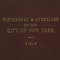
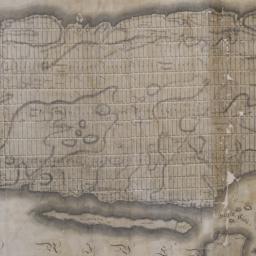
240. Topographical map of the City of New York showing original water courses and made land
Viele, Egbert L. 1825-1902
maps
- Name: Viele, Egbert L. 1825-1902
- Published: Ferd. Mayer & Co. lith: New York. c1865
- Format: maps
- Catalog Record: check availability
Search Other Sources for: "Manhattan (New York, N.Y.)"
Try your search in one of these related resources. (Search results will display in a new window.)
-
Avery Index to Architectural Periodicals
A comprehensive listing of journal articles published worldwide on architecture and design, archaeology, city planning, interior design, landscape architecture, and historic preservation. -
Brooklyn Historical Society Photography Collection
Search for individual photographs. Approximately 5,000 of our images are currently available online, but more images are added regularly. -
Brooklyn Public Library: Historic Brooklyn Photographs
Selection of more than ten thousand historic photographs from the Brooklyn Collection. -
CLIO: Columbia Libraries Catalog
Search for books, articles, journals, online resources and more. -
DLC: Columbia Libraries Digital Collections
A gateway to digital projects and online exhibitions that have been published on the web by Columbia University Libraries/Information Services (CUL/IS). -
Museum of the City of New York
Over 150,000 images and objects from the collections of the Museum of the City of New York.
Note: to come. -
New York Historical Society
Digital images from the library and museum collections. -
NYPL Digital Collections
Provides free and open access to over 800,000 images digitized from the The New York Public Library's vast collections.