Search Results Header
Search Constraints
Showing results for: Format maps Remove constraint Format: maps Format ephemera Remove constraint Format: ephemera Neighborhood Washington Heights North Remove constraint Neighborhood: Washington Heights North Borough Manhattan Remove constraint Borough: ManhattanSearch Results

1. Attacks of Fort Washington by His Majesty's forces under the command of Genl. Sir Willm Howe K.B. 16 Novr. 1776
maps
- Published: Lith. for D.T. Valentine's Manual for 1861 by Geo. Hayward: New York. [1861]
- Format: maps
- Online: click here for full-text
- Catalog Record: check availability
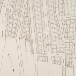
2. Map of 500 lots of the estate of James Cordon Bennett, dec'd, located between Broadway and N.Y. Central and Hudson River, RR. and between W. 181st and W. 187th Streets borough of Manhattan City of New York
maps
- Published: s.n: New York. 1919]
- Format: maps
- Online: click here for full-text
- Catalog Record: check availability

3. Metropolitan highways, New York -- New Jersey
Port of New York Authority
maps
- Name: Port of New York Authority
- Published: Port of New York Authority: New York. c1948
- Format: maps
- Catalog Record: check availability
4. Metropolitan New York road map
Port of New York Authority
maps
- Name: Port of New York Authority
- Published: Port of New York Authority: New York?. c1938
- Format: maps
- Catalog Record: check availability
5. Plan of the island of New York in North America but only from the eastern side in the vicinity of the late Fort Washington, afterward Knyphausen, which was taken in the month of May 1779 from the Laurel HIll, but first drawn in the month of January 1781 in the hut encampment near Fort Knyphausen
maps
- Published: Common Council: New York. 1854]
- Format: maps
- Catalog Record: check availability

6. [Seventeen miniature views of New York]
ephemera
- Published: s.n: New York?. 1939?]
- Format: ephemera
- Catalog Record: check availability
7. A souvenir of New York, the wonder city 20 assorted views
ephemera
- Published: D.R. & Co: New York. [1939?]
- Format: ephemera
- Catalog Record: check availability
8. [Stationery with views of New York City landmarks]
ephemera
- Published: s.n: New York?. 18--?]
- Format: ephemera
- Online: click here for full-text
- Catalog Record: check availability
9. A topographical map of the north part of New-York Island : exhibiting the plan of Fort Washington now Fort Knyphausen, with the rebels lines to the southward which where [sic] forced by the troops under the command of the Rt. Honble. Earl Percy on the 16th. Novr. 1776, and survey'd immediately after by order of his Lordship, to which is added the attack made to the north by the Hessians, surveyed by order of Lieut. Genl. Knyphausen
Sauthier, Claude Joseph
maps
- Name: Sauthier, Claude Joseph
- Published: D.T. Valentine?: N.Y.?. 1859]
- Format: maps
- Catalog Record: check availability
10. A topographical map of the northn. part of New York Island, exhibiting the plan of Fort Washington, now Fort Knyphausen, with the rebels lines to the southward, which were forced by the troops under the command of the Rt. Honble. Earl Percy on the 16th. Novr. 1776, and survey'd immediately after by order of His Lordship
Sauthier, Claude Joseph
maps
- Name: Sauthier, Claude Joseph
- Published: W. Faden: London. 1777
- Format: maps
- Online: click here for full-text
- Catalog Record: check availability
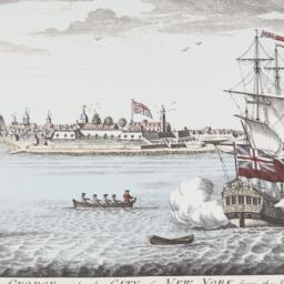
11. A view of Fort George with the City of New York from the SW
Carwitham, J
ephemera
- Name: Carwitham, J
- Published: s.n: New York?. 19uu]
- Format: ephemera
- Catalog Record: check availability