Search Results Header
Search Constraints
Showing results for: Format maps Remove constraint Format: maps Format ephemera Remove constraint Format: ephemera Borough Staten Island Remove constraint Borough: Staten Island Borough Manhattan Remove constraint Borough: Manhattan City New York Remove constraint City: New YorkSearch Results

1. Bay & port of New-York, capital of New-York
Bellin, Jacques Nicolas, 1703-1772
maps
- Name: Bellin, Jacques Nicolas, 1703-1772
- Published: Common Council: New York. 1861]
- Format: maps
- Catalog Record: check availability
2. The emergency map, family emergency map of New York City + emergency care guide : detailed 5-borough map with more than 70 hospitals, locations, 24-hour emergency rooms, special facilities, volunteer ambulance corps areas and phone numbers, directory of most-used emergency phone numbers, illustrated guide to basic emergency care procedures
Hagstrom Map Company
maps
- Name: Hagstrom Map Company
- Published: Hagstrom Map Co: Maspeth, N.Y. c1984
- Format: maps
- Catalog Record: check availability
3. Greater New York
National Geographic Society (U.S.). Cartographic Division
maps
- Name: National Geographic Society (U.S.). Cartographic Division
- Published: The Society: Washington. 1964
- Format: maps
- Catalog Record: check availability
4. Hagstrom's New York City : sites to see ... select walking tours to take
Hagstrom Map Company
maps
- Name: Hagstrom Map Company
- Published: Hagstrom Co: New York City, N.Y. [between 1970 and 1980?]
- Format: maps
- Catalog Record: check availability
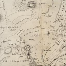
5. [Map of Manhattan, Brooklyn, Staten Island, Long Island, and New Jersey with references to the Battle on Long Island]
maps
- Published: s.n: New York?. 18--?]
- Format: maps
- Online: click here for full-text
- Catalog Record: check availability
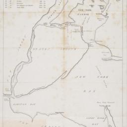
6. [Map of New York Harbor, New York Bay, and Staten Island]
maps
- Published: s.n: New York?. 18--?]
- Format: maps
- Online: click here for full-text
- Catalog Record: check availability
7. New York City, Manhattan, Brooklyn, Bronx, Queens & Staten Island map
Rand McNally and Company
maps
- Name: Rand McNally and Company
- Published: Rand McNally & Co: Chicago. [1982?]
- Format: maps
- Catalog Record: check availability
8. [New York, city map of New York and five boroughs]
Falk-Verlag
maps
- Name: Falk-Verlag
- Published: Falk-Plan: New York. [1969], c1968
- Format: maps
- Catalog Record: check availability

9. New York in 1768 south east view
Canot, Pierre Charles, 1710-1777
ephemera
- Name: Canot, Pierre Charles, 1710-1777
- Published: s.n: S.l. 18--?]
- Format: ephemera
- Catalog Record: check availability

10. New York in 1776 south east view
Canot, Pierre Charles, 1710-1777
ephemera
- Name: Canot, Pierre Charles, 1710-1777
- Published: s.n: S.l. 18--?]
- Format: ephemera
- Catalog Record: check availability
11. Rand McNally & Co.'s road map of the country around New York : including parts of northern and central New Jersey, Westchester County, Long Island, Staten Island, with the good roads specially marked
Rand McNally and Company
maps
- Name: Rand McNally and Company
- Published: Rand McNally: New York. c1894
- Format: maps
- Catalog Record: check availability