Search Results Header
Search Constraints
Showing results for: "Manhattan (New York, N.Y.)" Remove constraint "Manhattan (New York, N.Y.)" Format maps Remove constraint Format: maps Borough Manhattan Remove constraint Borough: Manhattan City New York Remove constraint City: New YorkSearch Results

1. 1609, the Island of Manhattan (Mannahtin) at the time of its discovery showing its elevations, water-courses, marshes, and shore line
MacCoun, Townsend, 1845-1932
maps
- Name: MacCoun, Townsend, 1845-1932
- Published: Townsend MacCoun: New York. c1909
- Format: maps
- Catalog Record: check availability

2. 1653-1664 Amsterdam in New Netherland the city of the Dutch West India Company
MacCoun, Townsend, 1845-1932
maps
- Name: MacCoun, Townsend, 1845-1932
- Published: Townsend MacCoun: New York. c1909
- Format: maps
- Online: click here for full-text
- Catalog Record: check availability
3. 1783, Manhattan Island at the close of the Revolution showing the American city with its landmarks and the Revolutionary fortifictions on the island
MacCoun, Townsend, 1845-1932
maps
- Name: MacCoun, Townsend, 1845-1932
- Published: L.L. Poates Engr'g Co: New York. c1909
- Format: maps
- Catalog Record: check availability
4. Asher & Adams' map of New York City
maps
- Published: Asher & Adams: New York?. between 1873 and 1883]
- Format: maps
- Online: click here for full-text
- Catalog Record: check availability
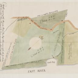
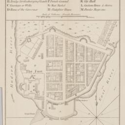
5. At the request of the recorder Thomas Jones Esqr. chairman, & the other gentlemen of the committee, I have surveyed the farm commonly called Tuttle Bay, granted by William Keist 23d of April 1646. unto George Holmes & Thomas Hall, and find the same to be agreeable to the above draft
Maerschalck, Francis W., -1776
maps
- Name: Maerschalck, Francis W., -1776
- Published: Common Council?: New York?. 1860?]
- Format: maps
- Online: click here for full-text
- Catalog Record: check availability
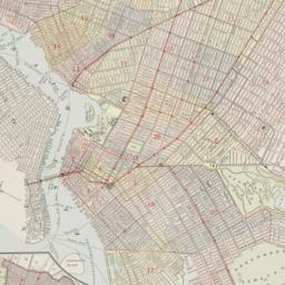
6. Atlas of the 16th, 18th, 20th & 21st Wards, city of New York : from actual surveys and official records
Pidgeon, R. H
maps
- Name: Pidgeon, R. H
- Published: E. Robinson: New York. 1880
- Format: maps
- Catalog Record: check availability
7. Atlas of the 19th & 22nd Wards, city of New York : from actual surveys and official records
G.W. Bromley & Co
maps
- Name: G.W. Bromley & Co
- Published: Published by Geo. W. & Walter S. Bromley: Phila. 1880
- Format: maps
- Catalog Record: check availability
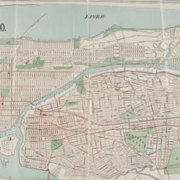
8. Atlas of the borough of Manhattan
G.W. Bromley & Co
maps
- Name: G.W. Bromley & Co
- Published: G.W. Bromley: New York. 1912
- Format: maps
- Online: click here for full-text click here for full-text click here for full-text
- Catalog Record: check availability
9. Atlas of the Borough of Manhattan, city of New York
G.W. Bromley & Co
maps
- Name: G.W. Bromley & Co
- Published: G. W. Bromley & Co: Philadelphia. [ca. 1921]
- Format: maps
- Catalog Record: check availability
10. Atlas of the Borough of Manhattan, City of New York : complete in four volumes, new and valuable additions and improvements not hitherto noticeable in previous atlases will be found prominent features of this work : the construction has been based upon maps on file, official plans and records carefully executed and thorough in all details : the field work also completed by competent and experienced engineers
E. Belcher Hyde (Firm)
maps
- Name: E. Belcher Hyde (Firm)
- Published: E. Belcher Hyde: Brooklyn. 1906-1907
- Format: maps
- Catalog Record: check availability
11. Attacks of Fort Washington by His Majesty's forces under the command of Genl. Sir Willm Howe K.B. 16 Novr. 1776
maps
- Published: Lith. for D.T. Valentine's Manual for 1861 by Geo. Hayward: New York. [1861]
- Format: maps
- Online: click here for full-text
- Catalog Record: check availability
12. Bay & port of New-York, capital of New-York
Bellin, Jacques Nicolas, 1703-1772
maps
- Name: Bellin, Jacques Nicolas, 1703-1772
- Published: Common Council: New York. 1861]
- Format: maps
- Catalog Record: check availability
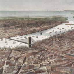
13. Bird's-eye view of the southern end of New York and Brooklyn, showing the projected suspension-bridge over the East River, from the western terminus in Printing-House Square, New York
Davis, Theodore R
maps
- Name: Davis, Theodore R
- Published: New York. 1870]
- Format: maps
- Online: click here for full-text
- Catalog Record: check availability
14. Boroughs of Manhattan and the Bronx showing the electric service of the New York Edison Co
maps
- Published: Bormay & Co: New York. [1902?]
- Format: maps
- Online: click here for full-text
- Catalog Record: check availability
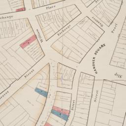
15. [Broad Street to Water Street south of Wall Street]
maps
- Published: s.n: New York?. 18--?]
- Format: maps
- Online: click here for full-text
- Catalog Record: check availability
16. Brooklyn
maps
- Published: E.F. Fisk: New York. [1890?]
- Format: maps
- Online: click here for full-text
- Catalog Record: check availability
17. Le centre de Manhattan, effets exclusifs à trois dimensions
Siegel, Norman L
maps
- Name: Siegel, Norman L
- Published: Able David Victor: New York. c1975
- Format: maps
- Catalog Record: check availability
18. Cimarron New York
maps
- Published: Incentra International Inc: New York. c1990
- Format: maps
- Catalog Record: check availability
19. City and county of New York
Bien, Joseph R
maps
- Name: Bien, Joseph R
- Published: Julius Bien & Co: New York. 1891]
- Format: maps
- Online: click here for full-text
- Catalog Record: check availability
20. City of Manhattan or New York
Bellin, Jacques Nicolas, 1703-1772
maps
- Name: Bellin, Jacques Nicolas, 1703-1772
- Published: Common Council: New York. 1861]
- Format: maps
- Online: click here for full-text
- Catalog Record: check availability
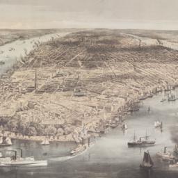
21. City of New York
Parsons, Charles, 1821-1910
maps
- Name: Parsons, Charles, 1821-1910
- Published: N. Currier: New York. 1856
- Format: maps
- Online: click here for full-text
- Catalog Record: check availability
22. The city of New York
Williams, J. W., active 1879
maps
- Name: Williams, J. W., active 1879
- Published: New York. ©1879
- Format: maps
- Online: click here for full-text
- Catalog Record: check availability
23. City of New York
Thomas, Cowperthwait & Co
maps
- Name: Thomas, Cowperthwait & Co
- Published: s.n.]: Philadelphia, Pa.?. 1850
- Format: maps
- Online: click here for full-text
- Catalog Record: check availability
24. City of New York
Burr, David H., 1803-1875
maps
- Name: Burr, David H., 1803-1875
- Published: J.H. Colton & Co: New York. 1839, c1833
- Format: maps
- Catalog Record: check availability
Search Other Sources for: "Manhattan (New York, N.Y.)"
Try your search in one of these related resources. (Search results will display in a new window.)
-
Avery Index to Architectural Periodicals
A comprehensive listing of journal articles published worldwide on architecture and design, archaeology, city planning, interior design, landscape architecture, and historic preservation. -
Brooklyn Historical Society Photography Collection
Search for individual photographs. Approximately 5,000 of our images are currently available online, but more images are added regularly. -
Brooklyn Public Library: Historic Brooklyn Photographs
Selection of more than ten thousand historic photographs from the Brooklyn Collection. -
CLIO: Columbia Libraries Catalog
Search for books, articles, journals, online resources and more. -
DLC: Columbia Libraries Digital Collections
A gateway to digital projects and online exhibitions that have been published on the web by Columbia University Libraries/Information Services (CUL/IS). -
Museum of the City of New York
Over 150,000 images and objects from the collections of the Museum of the City of New York.
Note: to come. -
New York Historical Society
Digital images from the library and museum collections. -
NYPL Digital Collections
Provides free and open access to over 800,000 images digitized from the The New York Public Library's vast collections.