Search Results Header
Search Constraints
Showing results for: "Westchester County (N.Y.)" Remove constraint "Westchester County (N.Y.)" Format maps Remove constraint Format: maps Borough Manhattan Remove constraint Borough: Manhattan City New York Remove constraint City: New YorkSearch Results

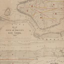
1. City and county of New York
Bien, Joseph R
maps
- Name: Bien, Joseph R
- Published: Julius Bien & Co: New York. 1891]
- Format: maps
- Online: click here for full-text
- Catalog Record: check availability
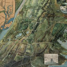
2. A general view of the Bronx River Parkway Reservation : as a connecting parkway between the park system of New York City, the Croton and Catskill watersheds, and the Harriman and Palisades Interstate Parks
New York (State). Bronx Parkway Commission
maps
- Name: New York (State). Bronx Parkway Commission
- Published: Bronx Parkway Commission: New York. 1915
- Format: maps
- Online: click here for full-text
- Catalog Record: check availability

3. Hydrographic map of the counties of New-York, Westchester and Putnam : and also showing the line of the Croton aqueduct
maps
- Published: Lith. by N. Currier, 152 Nassau cor. of Spruce: N[ew]Y[ork]. [1846?]
- Format: maps
- Catalog Record: check availability
4. Map of New York City : showing portions of Brooklyn, Jersey City, and Westchester Co. ; Rand, McNally & Co.'s guide map of New York City
Rand McNally and Company
maps
- Name: Rand McNally and Company
- Published: Rand, McNally & Co: Chicago. [1895], c1892
- Format: maps
- Catalog Record: check availability
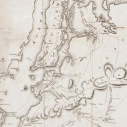
5. Map of New York I. : with the adjacent rocks and other remarkable parts of Hell-Gate
Kitchin, Thomas, 1718-1784
maps
- Name: Kitchin, Thomas, 1718-1784
- Published: Printed for R. Baldwin: London. [1778]
- Format: maps
- Online: click here for full-text
- Catalog Record: check availability
6. Map of the city & county of New York
Hayward, George, approximately 1800-
maps
- Name: Hayward, George, approximately 1800-
- Published: Engraved for D.T. Valentine's manual for 1862, by Geo. Hayward: New York (N.Y.). [1861]
- Format: maps
- Online: click here for full-text
- Catalog Record: check availability
7. New York island & parts adjacent
Conder, Thomas, 1746 or 1747-1831
maps
- Name: Conder, Thomas, 1746 or 1747-1831
- Published: Printed for the author: London. 1788]
- Format: maps
- Online: click here for full-text
- Catalog Record: check availability
8. A Plan of New York Island, Part of Long Island, &c. shewing the Position of the American and British Armies, before, at, and after the Engagement of the Heights, August 27th, 1776
Lewis, Samuel, 1753 or 1754-1822
maps
- Name: Lewis, Samuel, 1753 or 1754-1822
- Published: Richard Phillips: London?. 1806
- Format: maps
- Online: click here for full-text
- Catalog Record: check availability
9. A Plan of New York Island, Part of Long Island, &c. shewing the Position of the American and British Armies, before, at, and after the Engagement of the Heights, August 27th, 1776
Lewis, Samuel, 1753 or 1754-1822
maps
- Name: Lewis, Samuel, 1753 or 1754-1822
- Published: C.P. Wayne: Philadelphia. [1806]
- Format: maps
- Catalog Record: check availability
10. Rand McNally & Co.'s road map of the country around New York : including parts of northern and central New Jersey, Westchester County, Long Island, Staten Island, with the good roads specially marked
Rand McNally and Company
maps
- Name: Rand McNally and Company
- Published: Rand McNally: New York. c1894
- Format: maps
- Catalog Record: check availability
Search Other Sources for: "Westchester County (N.Y.)"
Try your search in one of these related resources. (Search results will display in a new window.)
-
Avery Index to Architectural Periodicals
A comprehensive listing of journal articles published worldwide on architecture and design, archaeology, city planning, interior design, landscape architecture, and historic preservation. -
Brooklyn Historical Society Photography Collection
Search for individual photographs. Approximately 5,000 of our images are currently available online, but more images are added regularly. -
Brooklyn Public Library: Historic Brooklyn Photographs
Selection of more than ten thousand historic photographs from the Brooklyn Collection. -
CLIO: Columbia Libraries Catalog
Search for books, articles, journals, online resources and more. -
DLC: Columbia Libraries Digital Collections
A gateway to digital projects and online exhibitions that have been published on the web by Columbia University Libraries/Information Services (CUL/IS). -
Museum of the City of New York
Over 150,000 images and objects from the collections of the Museum of the City of New York.
Note: to come. -
New York Historical Society
Digital images from the library and museum collections. -
NYPL Digital Collections
Provides free and open access to over 800,000 images digitized from the The New York Public Library's vast collections.