Search Results Header
Search Constraints
Showing results for: "Streets" Remove constraint "Streets" Format maps Remove constraint Format: maps Borough Manhattan Remove constraint Borough: ManhattanSearch Results

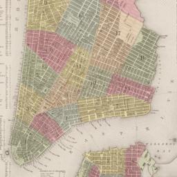
1. 1609, the Island of Manhattan (Mannahtin) at the time of its discovery showing its elevations, water-courses, marshes, and shore line
MacCoun, Townsend, 1845-1932
maps
- Name: MacCoun, Townsend, 1845-1932
- Published: Townsend MacCoun: New York. c1909
- Format: maps
- Catalog Record: check availability

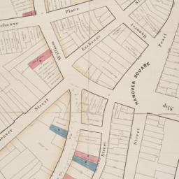
2. Asher & Adams' map of New York City
maps
- Published: Asher & Adams: New York?. between 1873 and 1883]
- Format: maps
- Online: click here for full-text
- Catalog Record: check availability
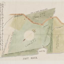
3. At the request of the recorder Thomas Jones Esqr. chairman, & the other gentlemen of the committee, I have surveyed the farm commonly called Tuttle Bay, granted by William Keist 23d of April 1646. unto George Holmes & Thomas Hall, and find the same to be agreeable to the above draft
Maerschalck, Francis W., -1776
maps
- Name: Maerschalck, Francis W., -1776
- Published: Common Council?: New York?. 1860?]
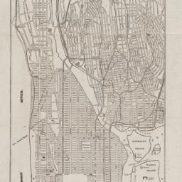
- Format: maps
- Online: click here for full-text
- Catalog Record: check availability
4. Atlas of the borough of Manhattan
G.W. Bromley & Co
maps
- Name: G.W. Bromley & Co
- Published: G.W. Bromley: New York. 1912
- Format: maps
- Online: click here for full-text click here for full-text click here for full-text
- Catalog Record: check availability
5. Atlas of the Borough of Manhattan, city of New York
G.W. Bromley & Co
maps
- Name: G.W. Bromley & Co
- Published: G. W. Bromley & Co: Philadelphia. [ca. 1921]
- Format: maps
- Catalog Record: check availability
6. [Broad Street to Water Street south of Wall Street]
maps
- Published: s.n: New York?. 18--?]
- Format: maps
- Online: click here for full-text
- Catalog Record: check availability
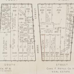
7. [Cadastral map of the area bound by South Street and Front Street between Whitehall Street and Broad Street]
maps
- Published: Chas. F. Noyes Co: New York. 1931?]
- Format: maps
- Online: click here for full-text
- Catalog Record: check availability
8. City and county of New York
Bien, Joseph R
maps
- Name: Bien, Joseph R
- Published: Julius Bien & Co: New York. 1891]
- Format: maps
- Online: click here for full-text
- Catalog Record: check availability
9. City of New York
Thomas, Cowperthwait & Co
maps
- Name: Thomas, Cowperthwait & Co
- Published: s.n.]: Philadelphia, Pa.?. 1850
- Format: maps
- Online: click here for full-text
- Catalog Record: check availability
10. City of New York
Burr, David H., 1803-1875
maps
- Name: Burr, David H., 1803-1875
- Published: J.H. Colton & Co: New York. 1839, c1833
- Format: maps
- Catalog Record: check availability
11. Cleartype street, house number, and transportation map of Manhattan (New York County, N.Y.)
American Map Company (New York, N.Y.)
maps
- Name: American Map Company (New York, N.Y.)
- Published: The Company: New York. [ca. 1948]
- Format: maps
- Catalog Record: check availability
12. Colton's Map of New York and the adjacent Cities
Colton, J. H. 1800-1893
maps
- Name: Colton, J. H. 1800-1893
- Published: Johnson & Browning: New York. c1855
- Format: maps
- Online: click here for full-text
- Catalog Record: check availability
13. Colton's New York City, Brooklyn, Jersey City, Hoboken, etc
Colton, G. Woolworth 1827-1901
maps
- Name: Colton, G. Woolworth 1827-1901
- Published: G.W. and C.B. Colton & Co: New York. 1875
- Format: maps
- Catalog Record: check availability
14. Cushman & Wakefield in Downtown Manhattan
Incentra International, Inc
maps
- Name: Incentra International, Inc
- Published: Cushman & Wakefield: New York. c1986
- Format: maps
- Catalog Record: check availability
15. C.W. Hobbs' guide map of New York City
Hobbs, C. W
maps
- Name: Hobbs, C. W
- Published: C.W. Hobbs: New York?. [between 1864 and 1884]
- Format: maps
- Online: click here for full-text
- Catalog Record: check availability
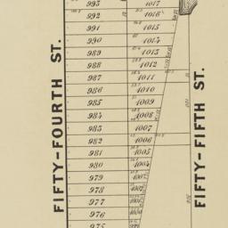
16. Extensive sale of lots of land located on Broadway, 7th 8th 9th, 10th and 11th Avenues and on 50th, 51st, 52d, 53d, and 54th Streets by order of the Supreme Court : under the direction of Philo. T. Ruggles, referee : Wednesday, June 18th, 1856, at 12 o'clock at the Merchants' Exchange
maps
- Published: Francis & Loutrel: New York?. [1856]
- Format: maps
- Online: click here for full-text
- Catalog Record: check availability
17. E-Z guide map of New York City : with patent indicator, showing at a glance the exact location of places of interest, railroad terminals, steamship piers, department stores and street locations
maps
- Published: Maull Co: Baltimore, Md. c1913
- Format: maps
- Catalog Record: check availability
18. E-Z guide map of New York City with patent indicator : showing at a glance the exact location of places of interest, railroad terminals, steamship piers, department stores and street locations
maps
- Published: Easy-Guide Mfg. Co: Baltimore, Md. c1916
- Format: maps
- Catalog Record: check availability
19. Hagstrom's map of New York theatres, hotels, shopping district
Hagstrom Company
maps
- Name: Hagstrom Company
- Published: Hagstrom Co: New York. [1944]
- Format: maps
- Catalog Record: check availability
20. Hamilton aerial map, Manhattan, New York City
Hamilton, W. L
maps
- Name: Hamilton, W. L
- Published: W.L. Hamilton: New York. [1927]
- Format: maps
- Catalog Record: check availability
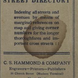
21. Hammond's new guide map of Manhattan and the Bronx
C.S. Hammond & Company
maps
- Name: C.S. Hammond & Company
- Published: C.S. Hammond & Co: New York. [between 1900 and 1930]
- Format: maps
- Catalog Record: check availability
22. Herald & Greeley Squares
maps
- Published: s.n: New York?. 1940]
- Format: maps
- Catalog Record: check availability
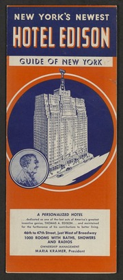
23. Hotel Edison, New York : part of Bronx and Queens showing World's Fair, indexed, house number map
Nostrand, George J
maps
- Name: Nostrand, George J
- Published: Hotel Edison?: New York?. 1939?]
- Format: maps
- Online: click here for full-text
- Catalog Record: check availability
24. Johnson's map of New York and the adjacent cities
Johnson and Ward
maps
- Name: Johnson and Ward
- Published: Johnson and Ward: New York. [1864?]
- Format: maps
- Online: click here for full-text
- Catalog Record: check availability
Search Other Sources for: "Streets"
Try your search in one of these related resources. (Search results will display in a new window.)
-
Avery Index to Architectural Periodicals
A comprehensive listing of journal articles published worldwide on architecture and design, archaeology, city planning, interior design, landscape architecture, and historic preservation. -
Brooklyn Historical Society Photography Collection
Search for individual photographs. Approximately 5,000 of our images are currently available online, but more images are added regularly. -
Brooklyn Public Library: Historic Brooklyn Photographs
Selection of more than ten thousand historic photographs from the Brooklyn Collection. -
CLIO: Columbia Libraries Catalog
Search for books, articles, journals, online resources and more. -
DLC: Columbia Libraries Digital Collections
A gateway to digital projects and online exhibitions that have been published on the web by Columbia University Libraries/Information Services (CUL/IS). -
Museum of the City of New York
Over 150,000 images and objects from the collections of the Museum of the City of New York.
Note: to come. -
New York Historical Society
Digital images from the library and museum collections. -
NYPL Digital Collections
Provides free and open access to over 800,000 images digitized from the The New York Public Library's vast collections.