Search Results Header
Search Constraints
Showing results for: "Aerial views" Remove constraint "Aerial views" Format maps Remove constraint Format: maps City New York Remove constraint City: New YorkSearch Results

1. Bird's eye view map of New York and vicinity
C.S. Hammond & Company
maps
- Name: C.S. Hammond & Company
- Published: C.S. Hammond & Co: New York. c1909
- Format: maps
- Catalog Record: check availability
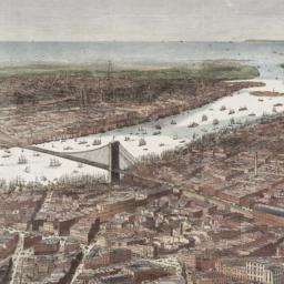
2. Bird's-eye view of the southern end of New York and Brooklyn, showing the projected suspension-bridge over the East River, from the western terminus in Printing-House Square, New York
Davis, Theodore R
maps
- Name: Davis, Theodore R
- Published: New York. 1870]
- Format: maps
- Online: click here for full-text
- Catalog Record: check availability
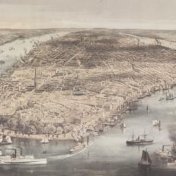
3. City of New York
Parsons, Charles, 1821-1910
maps
- Name: Parsons, Charles, 1821-1910
- Published: N. Currier: New York. 1856
- Format: maps
- Online: click here for full-text
- Catalog Record: check availability
4. The city of New York
Williams, J. W., active 1879
maps
- Name: Williams, J. W., active 1879
- Published: New York. ©1879
- Format: maps
- Online: click here for full-text
- Catalog Record: check availability
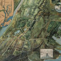
5. A general view of the Bronx River Parkway Reservation : as a connecting parkway between the park system of New York City, the Croton and Catskill watersheds, and the Harriman and Palisades Interstate Parks
New York (State). Bronx Parkway Commission
maps
- Name: New York (State). Bronx Parkway Commission
- Published: Bronx Parkway Commission: New York. 1915
- Format: maps
- Online: click here for full-text
- Catalog Record: check availability
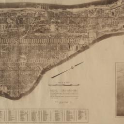
6. Hamilton aerial map, Manhattan, New York City
Hamilton, W. L
maps
- Name: Hamilton, W. L
- Published: W.L. Hamilton: New York. [1927]
- Format: maps
- Catalog Record: check availability
7. The Hamilton aerial map of Manhattan, New York City
Hamilton, W. L
maps
- Name: Hamilton, W. L
- Published: Hamilton Aeriel Maps: New York. c1928
- Format: maps
- Online: click here for full-text
- Catalog Record: check availability
8. New York
Bollmann, Hermann, 1911-1971
maps
- Name: Bollmann, Hermann, 1911-1971
- Published: Pictorial Maps: New York. [1962?]
- Format: maps
- Catalog Record: check availability
9. New York, map of midtown Manhattan : in detailed axonometric projection
Anderson Isometric Maps (Firm)
maps
- Name: Anderson Isometric Maps (Firm)
- Published: Anderson Isometric Maps: New York. c1980
- Format: maps
- Catalog Record: check availability
10. New York, picture and street map
Bollmann Bildkarten Verlag
maps
- Name: Bollmann Bildkarten Verlag
- Published: Bollmann-Bildkarten-Verlag: Braunschweig, Germany. [1984?]
- Format: maps
- Catalog Record: check availability
11. New York World's Fair : 1965 official souvenir map
Bollmann, Hermann, 1911-1971
maps
- Name: Bollmann, Hermann, 1911-1971
- Published: Time Inc: New York. c1965
- Format: maps
- Catalog Record: check availability
12. Plan of the island of New York in North America but only from the eastern side in the vicinity of the late Fort Washington, afterward Knyphausen, which was taken in the month of May 1779 from the Laurel HIll, but first drawn in the month of January 1781 in the hut encampment near Fort Knyphausen
maps
- Published: Common Council: New York. 1854]
- Format: maps
- Catalog Record: check availability
13. Supervue of New York City
Supervue Map & Guide Company
maps
- Name: Supervue Map & Guide Company
- Published: Supervue Map and Guide Organization: N.Y.C. c1937
- Format: maps
- Catalog Record: check availability
14. A walk on 53rd Street
maps
- Published: 53rd Street Association: New York. [1987?]
- Format: maps
- Catalog Record: check availability
Search Other Sources for: "Aerial views"
Try your search in one of these related resources. (Search results will display in a new window.)
-
Avery Index to Architectural Periodicals
A comprehensive listing of journal articles published worldwide on architecture and design, archaeology, city planning, interior design, landscape architecture, and historic preservation. -
Brooklyn Historical Society Photography Collection
Search for individual photographs. Approximately 5,000 of our images are currently available online, but more images are added regularly. -
Brooklyn Public Library: Historic Brooklyn Photographs
Selection of more than ten thousand historic photographs from the Brooklyn Collection. -
CLIO: Columbia Libraries Catalog
Search for books, articles, journals, online resources and more. -
DLC: Columbia Libraries Digital Collections
A gateway to digital projects and online exhibitions that have been published on the web by Columbia University Libraries/Information Services (CUL/IS). -
Museum of the City of New York
Over 150,000 images and objects from the collections of the Museum of the City of New York.
Note: to come. -
New York Historical Society
Digital images from the library and museum collections. -
NYPL Digital Collections
Provides free and open access to over 800,000 images digitized from the The New York Public Library's vast collections.