Search Results Header
Search Constraints
Showing results for: "Streets" Remove constraint "Streets" Format maps Remove constraint Format: maps Neighborhood Battery Park City-Lower Manhattan Remove constraint Neighborhood: Battery Park City-Lower ManhattanSearch Results
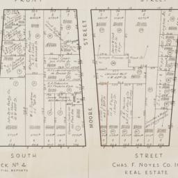
1. [Cadastral map of the area bound by South Street and Front Street between Whitehall Street and Broad Street]
maps
- Published: Chas. F. Noyes Co: New York. 1931?]
- Format: maps
- Online: click here for full-text
- Catalog Record: check availability

2. [Map of the area in Lower Manhattan bound by Pine Street, South Street, Wall Street and Front Street]
maps
- Published: s.n: New York?. 1895?]
- Format: maps
- Online: click here for full-text
- Catalog Record: check availability
3. [Broad Street to Water Street south of Wall Street]
maps
- Published: s.n: New York?. 18--?]
- Format: maps
- Online: click here for full-text
- Catalog Record: check availability
4. Map & plan of the proposed continuation of the widening & extension of William Street : from Maiden Lane to Chatham Street & the new line of said strt. as adopted between Wall St. & Maiden Lane, showing the situation of the property advertised by John R. Pitkin (No. 5 Broad Strt.)
maps
- Published: [publisher not identified]: N.Y.?. [183-?
- Format: maps
- Online: click here for full-text
- Catalog Record: check availability

5. [Map of Lower Manhattan, Pine Street to Rosevelt St. between South Street and William Street]
maps
- Published: s.n: New York?. 1930?]
- Format: maps
- Catalog Record: check availability
6. New-York, April 1852 drawn on an enlarged scale from map of district burnt by great fire of 16th Dec. 1835, as published in the Journal of Commerce Dec. 18th, 1835
maps
- Published: s.n: New York?. 1852?]
- Format: maps
- Online: click here for full-text
- Catalog Record: check availability
7. New York City--5 maps in 1 : Manhattan streets, Midtown, Downtown, Greenwich Village, Manhattan subways
Hagstrom Map Company
maps
- Name: Hagstrom Map Company
- Published: Hagstrom Map Co: Maspeth, NY. c1995
- Format: maps
- Catalog Record: check availability

8. A plan of the city of New-York
Holland, Samuel, 1728-1801
maps
- Name: Holland, Samuel, 1728-1801
- Published: D.T. Valentine: New York, N.Y. 1863]
- Format: maps
- Online: click here for full-text
- Catalog Record: check availability
9. Map and guide to lower Manhattan : from shoreline to skyline
Port Authority of New York and New Jersey
maps
- Name: Port Authority of New York and New Jersey
- Published: Port Authority of NY & NJ: New York?. c1988
- Format: maps
- Catalog Record: check availability
10. New York, 1730 the English colonial city
MacCoun, Townsend, 1845-1932
maps
- Name: MacCoun, Townsend, 1845-1932
- Published: Townsend MacCoun: New York. 1909
- Format: maps
- Online: click here for full-text
- Catalog Record: check availability
11. Cushman & Wakefield in Downtown Manhattan
Incentra International, Inc
maps
- Name: Incentra International, Inc
- Published: Cushman & Wakefield: New York. c1986
- Format: maps
- Catalog Record: check availability
12. A plan of the city of New York : reduced from an actual survey
Maerschalck, Francis W., -1776
maps
- Name: Maerschalck, Francis W., -1776
- Published: Lith. of H.R. Robinson for D.T. Valentine's Manual: New York, N.Y. [1850]
- Format: maps
- Online: click here for full-text
- Catalog Record: check availability
13. Plan of New York &c
Mitchell, S. Augustus, Jr
maps
- Name: Mitchell, S. Augustus, Jr
- Published: S. Augustus Mitchell, Jr: Philadelphia. 1860
- Format: maps
- Online: click here for full-text
- Catalog Record: check availability
14. A new & accurate plan of the City of New York in the State of New York in North America, published in 1797
New York (N.Y.). Common Council
maps
- Name: New York (N.Y.). Common Council
- Published: New York Common Council: New York. 1853]
- Format: maps
- Catalog Record: check availability
15. New Yorke, 1695
Miller, John, 1666-1724
maps
- Name: Miller, John, 1666-1724
- Published: Lith. G. Hayward: New York. [1852]
- Format: maps
- Online: click here for full-text
- Catalog Record: check availability
16. A plan of the city of New-York & its environs : to Greenwich, on the North or Hudsons River, and to Crown Point, on the East or Sound River, shewing the several streets, publick buildings, docks, fort & battery, with the true form & course of the commanding grounds, with and without the town
Montrésor, John, 1736-1799
maps
- Name: Montrésor, John, 1736-1799
- Published: Engraved from the original map by John Montresor for D.T. Valentine's Manual for 1855 by G. Hayward: New York, N.Y. [1855]
- Format: maps
- Online: click here for full-text
- Catalog Record: check availability
17. Plan of New York &c
Mitchell, S. Augustus, Jr
maps
- Name: Mitchell, S. Augustus, Jr
- Published: S. Augustus Mitchell, Jr: Philadelphia. c1866
- Format: maps
- Online: click here for full-text
- Catalog Record: check availability
18. City and county of New York
Bien, Joseph R
maps
- Name: Bien, Joseph R
- Published: Julius Bien & Co: New York. 1891]
- Format: maps
- Online: click here for full-text
- Catalog Record: check availability
19. Map of the city and county of New York : with the adjacent country
Burr, David H., 1803-1875
maps
- Name: Burr, David H., 1803-1875
- Published: s.n: New York. 1829]
- Format: maps
- Online: click here for full-text
- Catalog Record: check availability
20. Johnson's New York and Brooklyn
Johnson, A. J. 1827-1884
maps
- Name: Johnson, A. J. 1827-1884
- Published: A.J. Johnson: New York. c1866
- Format: maps
- Online: click here for full-text
- Catalog Record: check availability
Search Other Sources for: "Streets"
Try your search in one of these related resources. (Search results will display in a new window.)
-
Avery Index to Architectural Periodicals
A comprehensive listing of journal articles published worldwide on architecture and design, archaeology, city planning, interior design, landscape architecture, and historic preservation. -
Brooklyn Historical Society Photography Collection
Search for individual photographs. Approximately 5,000 of our images are currently available online, but more images are added regularly. -
Brooklyn Public Library: Historic Brooklyn Photographs
Selection of more than ten thousand historic photographs from the Brooklyn Collection. -
CLIO: Columbia Libraries Catalog
Search for books, articles, journals, online resources and more. -
DLC: Columbia Libraries Digital Collections
A gateway to digital projects and online exhibitions that have been published on the web by Columbia University Libraries/Information Services (CUL/IS). -
Museum of the City of New York
Over 150,000 images and objects from the collections of the Museum of the City of New York.
Note: to come. -
New York Historical Society
Digital images from the library and museum collections. -
NYPL Digital Collections
Provides free and open access to over 800,000 images digitized from the The New York Public Library's vast collections.