Search Results Header
Search Results

25. Atlas of Westchester County New York
Bien, Joseph R
maps
- Name: Bien, Joseph R
- Published: Julius Bien: New York. 1893
- Format: maps
- Catalog Record: check availability
26. Atlas of Westchester County, New York : from actual surveys and official records
G.W. Bromley & Co
maps
- Name: G.W. Bromley & Co
- Published: G.W. & W.S. Bromley: New York. 1881
- Format: maps
- Catalog Record: check availability

27. Atlas of Westchester County, N.Y.; pocket, desk and automobile edition
Bromley, George Washington
maps
- Name: Bromley, George Washington
- Published: G.W. Bromley & Co: New York. 1914
- Format: maps
- Online: click here for full-text click here for full-text
- Catalog Record: check availability
28. Attacks of Fort Washington by His Majesty's forces under the command of Genl. Sir Willm Howe K.B. 16 Novr. 1776
maps
- Published: Lith. for D.T. Valentine's Manual for 1861 by Geo. Hayward: New York. [1861]
- Format: maps
- Online: click here for full-text
- Catalog Record: check availability
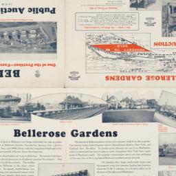
29. Auction map of Bellerose Gardens West in Nassau County, Long Island, N.Y. June 7th, 1926
maps
- Published: Realty Associates: Brooklyn, N.Y. [1926]
- Format: maps
- Online: click here for full-text
- Catalog Record: check availability
30. Automobile map of Hudson River district south
maps
- Published: Geo. H. Walker & Co: Boston. c1907
- Format: maps
- Online: click here for full-text
- Catalog Record: check availability
31. Bay & port of New-York, capital of New-York
Bellin, Jacques Nicolas, 1703-1772
maps
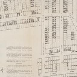
- Name: Bellin, Jacques Nicolas, 1703-1772
- Published: Common Council: New York. 1861]
- Format: maps
- Catalog Record: check availability
32. Bird's eye view map of New York and vicinity
C.S. Hammond & Company
maps
- Name: C.S. Hammond & Company
- Published: C.S. Hammond & Co: New York. c1909
- Format: maps
- Catalog Record: check availability
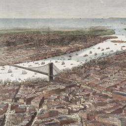
33. Bird's-eye view of the southern end of New York and Brooklyn, showing the projected suspension-bridge over the East River, from the western terminus in Printing-House Square, New York
Davis, Theodore R
maps
- Name: Davis, Theodore R
- Published: New York. 1870]
- Format: maps
- Online: click here for full-text
- Catalog Record: check availability
34. Block book of Twenty-Third Ward, New York City : for the use of real estate dealers, owners, lawyers, savings banks, insurance companies, and others intersted in New York City real estate : showing lots with their frontage and depths marked in feet an inches, block and ward numbers according to the tax maps in the City Assessor's office
Lediard, P. M
maps
- Name: Lediard, P. M
- Published: William T. Comstock: New York. [1920?]
- Format: maps
- Catalog Record: check availability
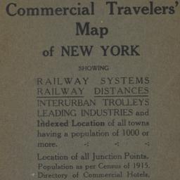
35. Blum's commercial travelers' map of New York
Blum, Max L
maps
- Name: Blum, Max L
- Published: Blum's Commercial Map Pub. Co: New York. c1920
- Format: maps
- Catalog Record: check availability
36. BMT Lines Rapid Transit Division
maps
- Published: BMT Lines: Brooklyn, N.Y. 1939]
- Format: maps
- Catalog Record: check availability
37. Boroughs of Manhattan and the Bronx showing the electric service of the New York Edison Co
maps
- Published: Bormay & Co: New York. [1902?]
- Format: maps
- Online: click here for full-text
- Catalog Record: check availability
38. Bowles's new pocket map of North America [facsimile] : divided into it's provinces, colonies, states, &c
Palairet, Jean, 1697-1774
maps
- Name: Palairet, Jean, 1697-1774
- Published: s.n: United States?. 1975?]
- Format: maps
- Catalog Record: check availability

39. Brewster & Company, Inc. (Bldg.) Rolls-Royce of America, Inc. (Ten.) (Garage) Long Island City New York
Associated Factory Mutual Fire Insurances Companies
maps
- Name: Associated Factory Mutual Fire Insurances Companies
- Published: Associated Factory Fire Insurance Companies: Boston, Mass. [1932]
- Format: maps
- Online: click here for full-text
- Catalog Record: check availability
40. [Broad Street to Water Street south of Wall Street]
maps
- Published: s.n: New York?. 18--?]
- Format: maps
- Online: click here for full-text
- Catalog Record: check availability
41. Bronx bus map : February 1995
New York City Transit Authority
maps
- Name: New York City Transit Authority
- Published: New York City Transit Authority: Brooklyn, NY. 1995
- Format: maps
- Catalog Record: check availability
42. Brooklyn
maps
- Published: E.F. Fisk: New York. [1890?]
- Format: maps
- Online: click here for full-text
- Catalog Record: check availability
43. Brooklyn bus map
New York City Transit Authority
maps
- Name: New York City Transit Authority
- Published: New York City Transit Authority: Brooklyn. c1994
- Format: maps
- Catalog Record: check availability
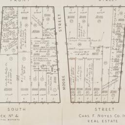
44. [Cadastral map of the area bound by South Street and Front Street between Whitehall Street and Broad Street]
maps
- Published: Chas. F. Noyes Co: New York. 1931?]
- Format: maps
- Online: click here for full-text
- Catalog Record: check availability
45. [Cadastral map of the lots at auction in the area between Broadway and Archer Avenue in White Plains, New York]
maps
- Published: American Photograph Company: New York. [1908]
- Format: maps
- Online: click here for full-text
- Catalog Record: check availability
46. Census tracts in the New York, N.Y., SMSA
United States. Bureau of the Census
maps
- Name: United States. Bureau of the Census
- Published: The Bureau: Washington. [1973?]
- Format: maps
- Catalog Record: check availability
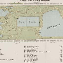
47. Central Park guide
maps
- Published: s.n: New York?. 1868?]
- Format: maps
- Online: click here for full-text
- Catalog Record: check availability
48. Le centre de Manhattan, effets exclusifs à trois dimensions
Siegel, Norman L
maps
- Name: Siegel, Norman L
- Published: Able David Victor: New York. c1975
- Format: maps
- Catalog Record: check availability