Search Results Header
Search Results

1. 1609, the Island of Manhattan (Mannahtin) at the time of its discovery showing its elevations, water-courses, marshes, and shore line
MacCoun, Townsend, 1845-1932
maps
- Name: MacCoun, Townsend, 1845-1932
- Published: Townsend MacCoun: New York. c1909
- Format: maps
- Catalog Record: check availability

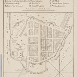
2. 1653-1664 Amsterdam in New Netherland the city of the Dutch West India Company
MacCoun, Townsend, 1845-1932
maps
- Name: MacCoun, Townsend, 1845-1932
- Published: Townsend MacCoun: New York. c1909
- Format: maps
- Online: click here for full-text
- Catalog Record: check availability
3. 1783, Manhattan Island at the close of the Revolution showing the American city with its landmarks and the Revolutionary fortifictions on the island
MacCoun, Townsend, 1845-1932
maps
- Name: MacCoun, Townsend, 1845-1932
- Published: L.L. Poates Engr'g Co: New York. c1909
- Format: maps
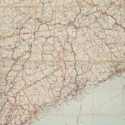
- Catalog Record: check availability
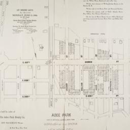
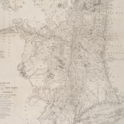
4. Adee Park east of Botanical Garden, Bronx Park : Borough of the Bronx, New York City
maps
- Published: s.n: New York?. 1906]
- Format: maps
- Online: click here for full-text
- Catalog Record: check availability
5. Asher & Adams' map of New York City
maps
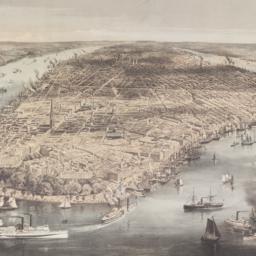
- Published: Asher & Adams: New York?. between 1873 and 1883]
- Format: maps
- Online: click here for full-text
- Catalog Record: check availability
6. Asher & Adams new topographical map of the state of New York made from official records and actual surveys
Asher & Adams
maps
- Name: Asher & Adams
- Published: Asher & Adams: New York. 1869
- Format: maps
- Catalog Record: check availability
7. Astoria : part of Long Island City, town of Newtown, Queens Co., L.I
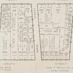
Beers, F. W
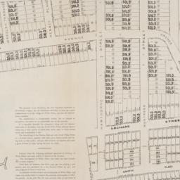
maps
- Name: Beers, F. W
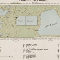
- Published: Beers, Comstock & Cline: New York. 1873]
- Format: maps
- Online: click here for full-text
- Catalog Record: check availability
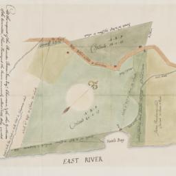
8. At the request of the recorder Thomas Jones Esqr. chairman, & the other gentlemen of the committee, I have surveyed the farm commonly called Tuttle Bay, granted by William Keist 23d of April 1646. unto George Holmes & Thomas Hall, and find the same to be agreeable to the above draft
Maerschalck, Francis W., -1776
maps
- Name: Maerschalck, Francis W., -1776
- Published: Common Council?: New York?. 1860?]
- Format: maps
- Online: click here for full-text
- Catalog Record: check availability
9. Atlas of Borough of the Bronx. from actual surveys and official plans / Sections 9 10 11 12 & 13
G.W. Bromley & Co
maps
- Name: G.W. Bromley & Co
- Published: G.W. Bromley & Co: Philadelphia. 1921
- Format: maps
- Catalog Record: check availability
10. Atlas of Staten Island, Richmond County, New York : From official records and surveys
J.B. Beers & Co
maps
- Name: J.B. Beers & Co
- Published: J. B. Beers & co: New York. 1874
- Format: maps
- Catalog Record: check availability
11. Atlas of the 16th, 18th, 20th & 21st Wards, city of New York : from actual surveys and official records
Pidgeon, R. H
maps
- Name: Pidgeon, R. H
- Published: E. Robinson: New York. 1880
- Format: maps
- Catalog Record: check availability
12. Atlas of the 19th & 22nd Wards, city of New York : from actual surveys and official records
G.W. Bromley & Co
maps
- Name: G.W. Bromley & Co
- Published: Published by Geo. W. & Walter S. Bromley: Phila. 1880
- Format: maps
- Catalog Record: check availability
13. Atlas of the 24th ward, city of New York : from actual surveys and official records
G.W. Bromley & Co
maps
- Name: G.W. Bromley & Co
- Published: Geo. W. & Walter S. Bromley: Philad[elphi]a. 1882
- Format: maps
- Catalog Record: check availability
14. Atlas of the borough of Manhattan
G.W. Bromley & Co
maps
- Name: G.W. Bromley & Co
- Published: G.W. Bromley: New York. 1912
- Format: maps
- Online: click here for full-text click here for full-text click here for full-text
- Catalog Record: check availability
15. Atlas of the Borough of Manhattan, city of New York
G.W. Bromley & Co
maps
- Name: G.W. Bromley & Co
- Published: G. W. Bromley & Co: Philadelphia. [ca. 1921]
- Format: maps
- Catalog Record: check availability
16. Atlas of the Borough of Manhattan, City of New York : complete in four volumes, new and valuable additions and improvements not hitherto noticeable in previous atlases will be found prominent features of this work : the construction has been based upon maps on file, official plans and records carefully executed and thorough in all details : the field work also completed by competent and experienced engineers
E. Belcher Hyde (Firm)
maps
- Name: E. Belcher Hyde (Firm)
- Published: E. Belcher Hyde: Brooklyn. 1906-1907
- Format: maps
- Catalog Record: check availability
17. Atlas of the borough of Queens, city of New York : based upon official plans and maps on file in the various city offices ; supplemented by careful field measurements and personal observations
Hyde, E. Belcher
maps
- Name: Hyde, E. Belcher
- Published: E. Belcher Hyde: Brooklyn. 1913-19
- Format: maps
- Catalog Record: check availability
18. Atlas of the Borough of the Bronx, City of New York : complete in five volumes
E. Belcher Hyde (Firm)
maps
- Name: E. Belcher Hyde (Firm)
- Published: The Company: Brooklyn. 1900-1927 [v. 1, 1907]
- Format: maps
- Catalog Record: check availability
19. Atlas of the city of New York : borough of the Bronx, annexed district from actual surveys and official plans
Bromley, George Washington
maps
- Name: Bromley, George Washington
- Published: G.W. Bromley: Philadelphia. 1905
- Format: maps
- Catalog Record: check availability
20. Atlas of the city of New York. : from official records private plans & actual surveys / volume 5, Embracing the 23rd ward
Robinson, E
maps
- Name: Robinson, E
- Published: E. Robinson: New York. 1887
- Format: maps
- Catalog Record: check availability
21. Atlas of the entire city of Brooklyn
G.W. Bromley & Co
maps
- Name: G.W. Bromley & Co
- Published: G. W. Bromley & E. Robinson: New York. 1880
- Format: maps
- Catalog Record: check availability
22. Atlas of the entire city of New York : complete in one volume ; from actual surveys and official records
G.W. Bromley & Co
maps
- Name: G.W. Bromley & Co
- Published: G. W. Bromley & E. Robinson: New York. 1879
- Format: maps
- Catalog Record: check availability
23. Atlas of the Metropolitan District and adjacent country comprising the counties of New York, Kings, Richmond, Westchester and part of Queens in the State of New York, the county of Hudson and parts of the counties of Bergen, Passaic, Essex and Union in the State of New Jersey : showing in a series of maps the relative geographical position, the topography, hydrography and economic features of this area
Bien, Joseph R
maps
- Name: Bien, Joseph R
- Published: J. Bien: New York. 1891
- Format: maps
- Catalog Record: check availability
24. An atlas of the state of New York : containing a map of the state and of the several counties, projected and drawn by a uniform scale from documents deposited in the public offices of the state and other original & authentic information, under the superintendance & direction of Simeon DeWitt, Surveyor General, pursuant to an act of the legislature and also the physical geography of the state & of the several counties & statistical tables of the same
Burr, David H., 1803-1875
maps
- Name: Burr, David H., 1803-1875
- Published: Published by David H. Burr: New York. 1829
- Format: maps
- Catalog Record: check availability
25. Atlas of Westchester County New York
Bien, Joseph R
maps
- Name: Bien, Joseph R
- Published: Julius Bien: New York. 1893
- Format: maps
- Catalog Record: check availability
26. Atlas of Westchester County, New York : from actual surveys and official records
G.W. Bromley & Co
maps
- Name: G.W. Bromley & Co
- Published: G.W. & W.S. Bromley: New York. 1881
- Format: maps
- Catalog Record: check availability
27. Atlas of Westchester County, N.Y.; pocket, desk and automobile edition
Bromley, George Washington
maps
- Name: Bromley, George Washington
- Published: G.W. Bromley & Co: New York. 1914
- Format: maps
- Online: click here for full-text click here for full-text
- Catalog Record: check availability
28. Attacks of Fort Washington by His Majesty's forces under the command of Genl. Sir Willm Howe K.B. 16 Novr. 1776
maps
- Published: Lith. for D.T. Valentine's Manual for 1861 by Geo. Hayward: New York. [1861]
- Format: maps
- Online: click here for full-text
- Catalog Record: check availability
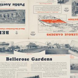
29. Auction map of Bellerose Gardens West in Nassau County, Long Island, N.Y. June 7th, 1926
maps
- Published: Realty Associates: Brooklyn, N.Y. [1926]
- Format: maps
- Online: click here for full-text
- Catalog Record: check availability
30. Automobile map of Hudson River district south
maps
- Published: Geo. H. Walker & Co: Boston. c1907
- Format: maps
- Online: click here for full-text
- Catalog Record: check availability
31. Bay & port of New-York, capital of New-York
Bellin, Jacques Nicolas, 1703-1772
maps
- Name: Bellin, Jacques Nicolas, 1703-1772
- Published: Common Council: New York. 1861]
- Format: maps
- Catalog Record: check availability
32. Bird's eye view map of New York and vicinity
C.S. Hammond & Company
maps
- Name: C.S. Hammond & Company
- Published: C.S. Hammond & Co: New York. c1909
- Format: maps
- Catalog Record: check availability
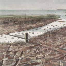
33. Bird's-eye view of the southern end of New York and Brooklyn, showing the projected suspension-bridge over the East River, from the western terminus in Printing-House Square, New York
Davis, Theodore R
maps
- Name: Davis, Theodore R
- Published: New York. 1870]
- Format: maps
- Online: click here for full-text
- Catalog Record: check availability
34. Block book of Twenty-Third Ward, New York City : for the use of real estate dealers, owners, lawyers, savings banks, insurance companies, and others intersted in New York City real estate : showing lots with their frontage and depths marked in feet an inches, block and ward numbers according to the tax maps in the City Assessor's office
Lediard, P. M
maps
- Name: Lediard, P. M
- Published: William T. Comstock: New York. [1920?]
- Format: maps
- Catalog Record: check availability
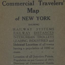
35. Blum's commercial travelers' map of New York
Blum, Max L
maps
- Name: Blum, Max L
- Published: Blum's Commercial Map Pub. Co: New York. c1920
- Format: maps
- Catalog Record: check availability
36. BMT Lines Rapid Transit Division
maps
- Published: BMT Lines: Brooklyn, N.Y. 1939]
- Format: maps
- Catalog Record: check availability
37. Boroughs of Manhattan and the Bronx showing the electric service of the New York Edison Co
maps
- Published: Bormay & Co: New York. [1902?]
- Format: maps
- Online: click here for full-text
- Catalog Record: check availability
38. Bowles's new pocket map of North America [facsimile] : divided into it's provinces, colonies, states, &c
Palairet, Jean, 1697-1774
maps
- Name: Palairet, Jean, 1697-1774
- Published: s.n: United States?. 1975?]
- Format: maps
- Catalog Record: check availability

39. Brewster & Company, Inc. (Bldg.) Rolls-Royce of America, Inc. (Ten.) (Garage) Long Island City New York
Associated Factory Mutual Fire Insurances Companies
maps
- Name: Associated Factory Mutual Fire Insurances Companies
- Published: Associated Factory Fire Insurance Companies: Boston, Mass. [1932]
- Format: maps
- Online: click here for full-text
- Catalog Record: check availability
40. [Broad Street to Water Street south of Wall Street]
maps
- Published: s.n: New York?. 18--?]
- Format: maps
- Online: click here for full-text
- Catalog Record: check availability
41. Bronx bus map : February 1995
New York City Transit Authority
maps
- Name: New York City Transit Authority
- Published: New York City Transit Authority: Brooklyn, NY. 1995
- Format: maps
- Catalog Record: check availability
42. Brooklyn
maps
- Published: E.F. Fisk: New York. [1890?]
- Format: maps
- Online: click here for full-text
- Catalog Record: check availability
43. Brooklyn bus map
New York City Transit Authority
maps
- Name: New York City Transit Authority
- Published: New York City Transit Authority: Brooklyn. c1994
- Format: maps
- Catalog Record: check availability
44. [Cadastral map of the area bound by South Street and Front Street between Whitehall Street and Broad Street]
maps
- Published: Chas. F. Noyes Co: New York. 1931?]
- Format: maps
- Online: click here for full-text
- Catalog Record: check availability
45. [Cadastral map of the lots at auction in the area between Broadway and Archer Avenue in White Plains, New York]
maps
- Published: American Photograph Company: New York. [1908]
- Format: maps
- Online: click here for full-text
- Catalog Record: check availability
46. Census tracts in the New York, N.Y., SMSA
United States. Bureau of the Census
maps
- Name: United States. Bureau of the Census
- Published: The Bureau: Washington. [1973?]
- Format: maps
- Catalog Record: check availability
47. Central Park guide
maps
- Published: s.n: New York?. 1868?]
- Format: maps
- Online: click here for full-text
- Catalog Record: check availability
48. Le centre de Manhattan, effets exclusifs à trois dimensions
Siegel, Norman L
maps
- Name: Siegel, Norman L
- Published: Able David Victor: New York. c1975
- Format: maps
- Catalog Record: check availability
49. Certified copies of original maps of property in New York City, filed in the register's office and elsewhere, together with the register's index to maps and important notes regarding the same
Spielmann & Brush
maps
- Name: Spielmann & Brush
- Published: Spielmann & Brush: Hoboken, N.J. 1881
- Format: maps
- Catalog Record: check availability
50. Chinatown map + guide : history, walking tour, restaurants, shops
Blutreich, Ira
maps
- Name: Blutreich, Ira
- Published: Iris' Art Studio: New York, N.Y. c1984
- Format: maps
- Catalog Record: check availability
51. A chorographical map of the Province of New York in North America : divided into counties, manors, patents and townships ; exhibiting likewise all the private grants of land made and located in that Province ; compiled from actual surveys deposited in the Patent Office at New York, by order of His Excellency Major General William Tryon
Sauthier, Claude Joseph
maps
- Name: Sauthier, Claude Joseph
- Published: Richard H. Pease: Albany. 1849
- Format: maps
- Online: click here for full-text
- Catalog Record: check availability
52. Cimarron New York
maps
- Published: Incentra International Inc: New York. c1990
- Format: maps
- Catalog Record: check availability
53. Citizens & travelers guide map in, to, and from the city of New York and adjacent places
D.A. Edsall & Co
maps
- Name: D.A. Edsall & Co
- Published: D.A. Edsall & Co: New York. 1877
- Format: maps
- Catalog Record: check availability
54. City and county of New York
Bien, Joseph R
maps
- Name: Bien, Joseph R
- Published: Julius Bien & Co: New York. 1891]
- Format: maps
- Online: click here for full-text
- Catalog Record: check availability
55. City of Manhattan or New York
Bellin, Jacques Nicolas, 1703-1772
maps
- Name: Bellin, Jacques Nicolas, 1703-1772
- Published: Common Council: New York. 1861]
- Format: maps
- Online: click here for full-text
- Catalog Record: check availability
56. City of New York
Parsons, Charles, 1821-1910
maps
- Name: Parsons, Charles, 1821-1910
- Published: N. Currier: New York. 1856
- Format: maps
- Online: click here for full-text
- Catalog Record: check availability
57. The city of New York
Williams, J. W., active 1879
maps
- Name: Williams, J. W., active 1879
- Published: New York. ©1879
- Format: maps
- Online: click here for full-text
- Catalog Record: check availability
58. City of New York
Thomas, Cowperthwait & Co
maps
- Name: Thomas, Cowperthwait & Co
- Published: s.n.]: Philadelphia, Pa.?. 1850
- Format: maps
- Online: click here for full-text
- Catalog Record: check availability
59. City of New York
Burr, David H., 1803-1875
maps
- Name: Burr, David H., 1803-1875
- Published: J.H. Colton & Co: New York. 1839, c1833
- Format: maps
- Catalog Record: check availability
60. City of New-York
Burr, David H., 1803-1875
maps
- Name: Burr, David H., 1803-1875
- Published: Republished by W.P. Stone: Ithaca, N.Y. 1838
- Format: maps
- Online: click here for full-text
- Catalog Record: check availability