Search Results Header
Search Constraints
Showing results for: Format other Remove constraint Format: other Format maps Remove constraint Format: maps Format objects Remove constraint Format: objects Borough Queens Remove constraint Borough: QueensSearch Results

1. Asher & Adams' map of New York City
maps
- Published: Asher & Adams: New York?. between 1873 and 1883]
- Format: maps
- Online: click here for full-text
- Catalog Record: check availability
2. Astoria : part of Long Island City, town of Newtown, Queens Co., L.I
Beers, F. W
maps
- Name: Beers, F. W
- Published: Beers, Comstock & Cline: New York. 1873]
- Format: maps
- Online: click here for full-text
- Catalog Record: check availability

3. BMT Lines Rapid Transit Division
maps
- Published: BMT Lines: Brooklyn, N.Y. 1939]
- Format: maps
- Catalog Record: check availability
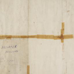
4. Brewster & Company, Inc. (Bldg.) Rolls-Royce of America, Inc. (Ten.) (Garage) Long Island City New York
Associated Factory Mutual Fire Insurances Companies
maps
- Name: Associated Factory Mutual Fire Insurances Companies
- Published: Associated Factory Fire Insurance Companies: Boston, Mass. [1932]
- Format: maps
- Online: click here for full-text
- Catalog Record: check availability
5. Colton's Map of New York and the adjacent Cities
Colton, J. H. 1800-1893
maps
- Name: Colton, J. H. 1800-1893
- Published: Johnson & Browning: New York. c1855
- Format: maps
- Online: click here for full-text
- Catalog Record: check availability
6. The emergency map, family emergency map of New York City + emergency care guide : detailed 5-borough map with more than 70 hospitals, locations, 24-hour emergency rooms, special facilities, volunteer ambulance corps areas and phone numbers, directory of most-used emergency phone numbers, illustrated guide to basic emergency care procedures
Hagstrom Map Company
maps
- Name: Hagstrom Map Company
- Published: Hagstrom Map Co: Maspeth, N.Y. c1984
- Format: maps
- Catalog Record: check availability
7. Greater New York
National Geographic Society (U.S.). Cartographic Division
maps
- Name: National Geographic Society (U.S.). Cartographic Division
- Published: The Society: Washington. 1964
- Format: maps
- Catalog Record: check availability
8. Guide map to the Brooklyn and Queens parks
maps
- Published: s.n: New York?. between 1925 and 1939]
- Format: maps
- Catalog Record: check availability
9. Hagstrom's New York City : sites to see ... select walking tours to take
Hagstrom Map Company
maps
- Name: Hagstrom Map Company
- Published: Hagstrom Co: New York City, N.Y. [between 1970 and 1980?]
- Format: maps
- Catalog Record: check availability
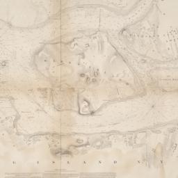
10. Hell Gate and its approaches
United States Coast Survey
maps
- Name: United States Coast Survey
- Published: U.S. Coast Survey: Washington. 1853
- Format: maps
- Online: click here for full-text
- Catalog Record: check availability

11. Hotel Astor, New York
objects
- Published: s.n: New York?. between 1904 and 1967]
- Format: objects
- Catalog Record: check availability
12. How to see the New York World's Fair quickly, comfortably, completely
New York World's Fair 1964-1965 Corporation
maps
- Name: New York World's Fair 1964-1965 Corporation
- Published: New York World's Fair 1964-1965 Corp: New York?. 1964
- Format: maps
- Catalog Record: check availability
13. Hunters Point, part of Long Island City
maps
- Published: Beers, Comstock & Cline: N.Y. 1873]
- Format: maps
- Online: click here for full-text click here for full-text
- Catalog Record: check availability
14. John F. Kennedy International Airport bus map
Tauranac, Ltd
maps
- Name: Tauranac, Ltd
- Published: Port Authority of NY & NJ, Office of Ground Transportation: New York. c1991
- Format: maps
- Catalog Record: check availability
15. Johnson's New York and Brooklyn
Johnson, A. J. 1827-1884
maps
- Name: Johnson, A. J. 1827-1884
- Published: A.J. Johnson: New York. c1866
- Format: maps
- Online: click here for full-text
- Catalog Record: check availability
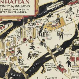
16. A man's map of Manhattan and vicinity by Wallach's
Voorhies, Stephen J
maps
- Name: Voorhies, Stephen J
- Format: maps
- Catalog Record: check availability
17. A man's map of New York by Wallach's
Voorhies, Stephen J
maps
- Name: Voorhies, Stephen J
- Format: maps
- Catalog Record: check availability
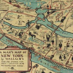
18. A man's map of New York by Wallach's
Voorhies, Stephen J
maps
- Name: Voorhies, Stephen J
- Format: maps
- Catalog Record: check availability
19. Map of New York City
maps
- Published: Hunt & Eaton: New York?. c1891
- Format: maps
- Online: click here for full-text
- Catalog Record: check availability
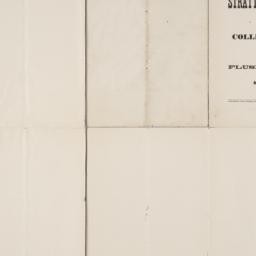
20. Map of Stratton Bluffs at College Point on Flushing Bay, New York
maps
- Published: John Meddle & Son: New York. [1891]
- Format: maps
- Online: click here for full-text
- Catalog Record: check availability
21. A map of the city and county of New York : with the adjacent cities of Brooklyn and Jersey City, and the village of Williamsburg : with a street directory of the city of New York
Thayer, Bridgman & Fanning
maps
- Name: Thayer, Bridgman & Fanning
- Published: Thayer, Bridgman & Fanning: New York. 1853
- Format: maps
- Catalog Record: check availability
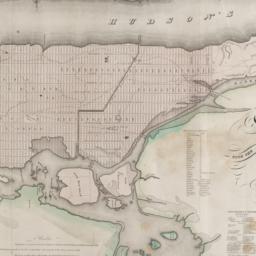
22. Map of the city and county of New York : with the adjacent country
Burr, David H., 1803-1875
maps
- Name: Burr, David H., 1803-1875
- Published: s.n: New York. 1829]
- Format: maps
- Online: click here for full-text
- Catalog Record: check availability
23. Map of the subway system of New York
Voorhies, Stephen J
maps
- Name: Voorhies, Stephen J
- Published: Union Dime Savings Bank: New York. 1940
- Format: maps
- Catalog Record: check availability
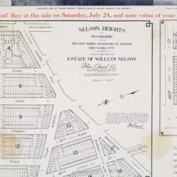
24. Nelson Heights at Woodside in the Second Ward, borough of Queens, New York City
maps
- Published: William Kennely, Inc: New York. [1926]
- Format: maps
- Online: click here for full-text
- Catalog Record: check availability