Search Results Header
Search Constraints
Showing results for: Format other Remove constraint Format: other Format periodicals Remove constraint Format: periodicals Format maps Remove constraint Format: maps Format ephemera Remove constraint Format: ephemera Format objects Remove constraint Format: objects Format music Remove constraint Format: music Borough Staten Island Remove constraint Borough: Staten IslandSearch Results

1. Atlas of Staten Island, Richmond County, New York : From official records and surveys
J.B. Beers & Co
maps
- Name: J.B. Beers & Co
- Published: J. B. Beers & co: New York. 1874
- Format: maps
- Catalog Record: check availability
2. Bay & port of New-York, capital of New-York
Bellin, Jacques Nicolas, 1703-1772
maps
- Name: Bellin, Jacques Nicolas, 1703-1772
- Published: Common Council: New York. 1861]
- Format: maps
- Catalog Record: check availability
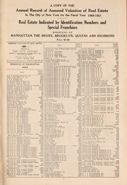
3. A Copy of the annual record of assessed valuation of real estate in the City of New York for the fiscal year ... Real estate indicated by identification numbers and special franchises : Boroughs of Manhattan, the Bronx, Brooklyn, Queens and Richmond
periodicals
- Published: City record]: New York City. 1947-
- Format: periodicals
- Online: click here for full-text
- Catalog Record: check availability

4. La destruction de la statue royale a Nouvelle Yorck Die zerstorung der koniglichen bild saule zu Neu Yorck
ephemera
- Published: Chez Basset, Rue St. Jacques: Paris. [177-]
- Format: ephemera
- Catalog Record: check availability
5. The emergency map, family emergency map of New York City + emergency care guide : detailed 5-borough map with more than 70 hospitals, locations, 24-hour emergency rooms, special facilities, volunteer ambulance corps areas and phone numbers, directory of most-used emergency phone numbers, illustrated guide to basic emergency care procedures
Hagstrom Map Company
maps
- Name: Hagstrom Map Company
- Published: Hagstrom Map Co: Maspeth, N.Y. c1984
- Format: maps
- Catalog Record: check availability
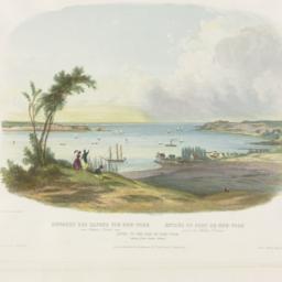
6. Entry to the Bay of New-York taken from Staten Island einfahrt des Hafens von New-York von Staten Island aus = entrée du Port de New-York prise de Staten Island
Bodmer, Karl, 1809-1893
ephemera
- Name: Bodmer, Karl, 1809-1893
- Published: Ackermann & Co: London. 1839
- Format: ephemera
- Catalog Record: check availability
7. Greater New York
National Geographic Society (U.S.). Cartographic Division
maps
- Name: National Geographic Society (U.S.). Cartographic Division
- Published: The Society: Washington. 1964
- Format: maps
- Catalog Record: check availability
8. Hagstrom's New York City : sites to see ... select walking tours to take
Hagstrom Map Company
maps
- Name: Hagstrom Map Company
- Published: Hagstrom Co: New York City, N.Y. [between 1970 and 1980?]
- Format: maps
- Catalog Record: check availability
9. [Map of Manhattan, Brooklyn, Staten Island, Long Island, and New Jersey with references to the Battle on Long Island]
maps
- Published: s.n: New York?. 18--?]
- Format: maps
- Online: click here for full-text
- Catalog Record: check availability
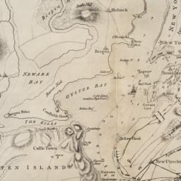
10. [Map of New York Harbor, New York Bay, and Staten Island]
maps
- Published: s.n: New York?. 18--?]
- Format: maps
- Online: click here for full-text
- Catalog Record: check availability

11. The metropolis and its surroundings showing Staten Island and the New Baltimore and Ohio railroad line to New York directly connecting with all the elevated railways in the City and most convenient to every route in and through New York and Brooklyn
maps
- Published: s.n: New York?. 1885?]
- Format: maps
- Online: click here for full-text
- Catalog Record: check availability

12. The most remarkable waterfront sites in New York City
ephemera
- Published: s.n: New York?. 1984]
- Format: ephemera
- Catalog Record: check availability
13. New York City, Manhattan, Brooklyn, Bronx, Queens & Staten Island map
Rand McNally and Company
maps
- Name: Rand McNally and Company
- Published: Rand McNally & Co: Chicago. [1982?]
- Format: maps
- Catalog Record: check availability
14. [New York, city map of New York and five boroughs]
Falk-Verlag
maps
- Name: Falk-Verlag
- Published: Falk-Plan: New York. [1969], c1968
- Format: maps
- Catalog Record: check availability

15. New York in 1768 south east view
Canot, Pierre Charles, 1710-1777
ephemera
- Name: Canot, Pierre Charles, 1710-1777
- Published: s.n: S.l. 18--?]
- Format: ephemera
- Catalog Record: check availability

16. New York in 1776 south east view
Canot, Pierre Charles, 1710-1777
ephemera
- Name: Canot, Pierre Charles, 1710-1777
- Published: s.n: S.l. 18--?]
- Format: ephemera
- Catalog Record: check availability

17. Progress report on Kill Van Kull Bridge between Bayonne, N. J., and Port Richmond, Staten Island, N. Y
Port of New York Authority
periodicals
- Name: Port of New York Authority
- Published: Port of New York Authority: New York City. 1930-
- Format: periodicals
- Online: click here for full-text
- Catalog Record: check availability
18. Public parks boroughs of Manhattan and Richmond City of New York
maps
- Published: s.n: New York?. 1903?]
- Format: maps
- Catalog Record: check availability
19. Rand McNally & Co.'s road map of the country around New York : including parts of northern and central New Jersey, Westchester County, Long Island, Staten Island, with the good roads specially marked
Rand McNally and Company
maps
- Name: Rand McNally and Company
- Published: Rand McNally: New York. c1894
- Format: maps
- Catalog Record: check availability