Search Results Header
Search Results
Notice: Access to some items may be restricted because of copyright. Members of the Columbia Community can log in and learn about the Terms of Use.
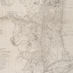
1. A chorographical map of the Province of New York in North America : divided into counties, manors, patents and townships ; exhibiting likewise all the private grants of land made and located in that Province ; compiled from actual surveys deposited in the Patent Office at New York, by order of His Excellency Major General William Tryon
Sauthier, Claude Joseph
- Name: Sauthier, Claude Joseph
- Collection Name: Seymour B. Durst Old York Library Collection
- Date: 1849
- Item in Context: https://dlc.library.columbia.edu/durst/cul:79cnp5hqcm