Search Results Header
Search Results
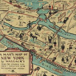
121. A man's map of New York by Wallach's
Voorhies, Stephen J
maps
- Name: Voorhies, Stephen J
- Format: maps
- Catalog Record: check availability
122. Map & plan of the proposed continuation of the widening & extension of William Street : from Maiden Lane to Chatham Street & the new line of said strt. as adopted between Wall St. & Maiden Lane, showing the situation of the property advertised by John R. Pitkin (No. 5 Broad Strt.)
maps
- Published: [publisher not identified]: N.Y.?. [183-?
- Format: maps
- Online: click here for full-text
- Catalog Record: check availability
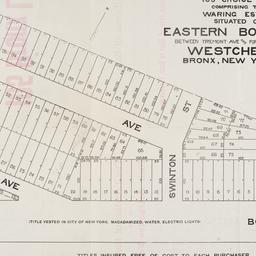
123. Map of 105 choice lots comprising the Waring Estate situated on Eastern Boulevard between Tremont Ave and Fort Schuyler Road Westchester Bronx, New York City
maps
- Published: s.n: New York. 1906]
- Format: maps
- Online: click here for full-text
- Catalog Record: check availability

124. Map of 158 building lots at Harlaem [sic] to be sold by James Bleeckeer & Sons on Wednesday January 15th at 12 o'clock at the Merchts Exchange
maps
- Published: P. Desbroy's: New York. [18--?]
- Format: maps
- Online: click here for full-text
- Catalog Record: check availability
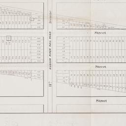
125. Map of 500 lots of the estate of James Cordon Bennett, dec'd, located between Broadway and N.Y. Central and Hudson River, RR. and between W. 181st and W. 187th Streets borough of Manhattan City of New York
maps
- Published: s.n: New York. 1919]
- Format: maps
- Online: click here for full-text
- Catalog Record: check availability
126. [Map of 50th Street to 53rd Street between 10th Avenue and 13th Avenue]
maps
- Published: s.n: New York?. 1851?]
- Format: maps
- Online: click here for full-text
- Catalog Record: check availability

127. Map of 58 lots belonging to the Griswold Estate fronting on the continuation of Riverside Drive known as Fieldston Road and situated between Broadway and Riverdale Avenue, W. 246th Street and W. 253rd Street
maps
- Published: s.n: New. 1910]
- Format: maps
- Online: click here for full-text
- Catalog Record: check availability
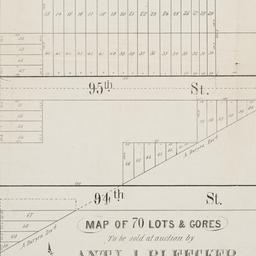
128. Map of 70 lots & gores to be sold at auction by Aty J. Bleecker on Monday 25th March 1850 at 12 o'clock at the Merchants Exchange
maps
- Published: Serrell & Perkins: New York. [1850]
- Format: maps
- Online: click here for full-text
- Catalog Record: check availability

129. Map of 80 acres of land situate in the 12th Ward of the city of New York part of the estate of Isaac Dyckman, dec'd : known as the "Part 3rd of the Dyckman Homestead Property" to be sold by V.K. Stevenson Son & Co, B.P. Fairchild, Auctioneer, June 7th, 1871 at the Exchange Salesrooms, 111 Broadway, New York
maps
- Published: Major & Knapp Eng. Mfg. & Lith. Co: New York. [1871]
- Format: maps
- Online: click here for full-text
- Catalog Record: check availability
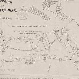
130. Map of Brooklyn at the time of the Revolutionary War
Johnson, Jeremiah, 1768-1852
maps
- Name: Johnson, Jeremiah, 1768-1852
- Published: George Hayward: N[ew] Y[ork]. [1858]
- Format: maps
- Online: click here for full-text
- Catalog Record: check availability
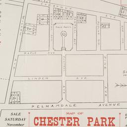
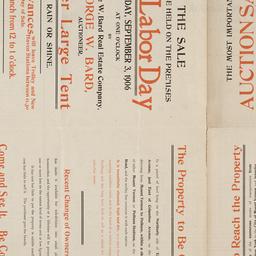
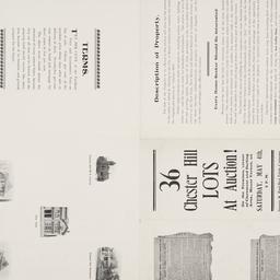
131. Map of Chester Park 41 lots to sold at auction by George W. Bard, auctioneer
maps
- Published: s.n: New York. 18--?]
- Format: maps
- Online: click here for full-text
- Catalog Record: check availability
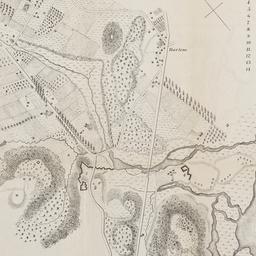
132. Map of Harlem Heights and plain, 1814
maps
- Published: [publisher not identified]: Place of publication not identified. [1856?]
- Format: maps
- Catalog Record: check availability
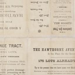
133. [Map of Hudson Avenue Tract in Newark]
maps
- Published: s.n: Newark, N.J.?. 18--?]
- Format: maps
- Online: click here for full-text
- Catalog Record: check availability

134. Map of land belonging to the Odell Realty Co. in the city of Yonkers, N.Y
maps
- Published: s.n: New York?. 1913?]
- Format: maps
- Online: click here for full-text
- Catalog Record: check availability
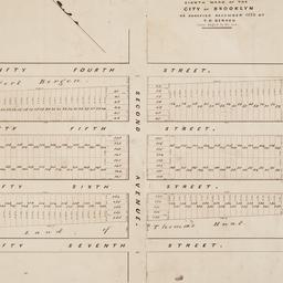
135. Map of land of Theodorus Bergen west of Third Avenue in the Eighth Ward of the city of Brooklyn : as surveyed December 1853 by T.G. Bergen
Bergen, Teunis G., 1806-1881
maps
- Name: Bergen, Teunis G., 1806-1881
- Format: maps
- Catalog Record: check availability
136. Map of Lincoln Manor City of Mount Vernon, Westchester Co., N.Y
maps
- Published: s.n: New York. 1906]
- Format: maps
- Online: click here for full-text
- Catalog Record: check availability

137. Map of lower New York City showing the location of the Knickerbocker
maps
- Published: Hagstrom Map Co: New York?. 19--?]
- Format: maps
- Online: click here for full-text
- Catalog Record: check availability
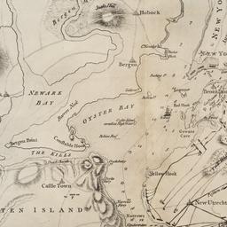
138. [Map of Manhattan, Brooklyn, Staten Island, Long Island, and New Jersey with references to the Battle on Long Island]
maps
- Published: s.n: New York?. 18--?]
- Format: maps
- Online: click here for full-text
- Catalog Record: check availability
139. Map of Mount Vernon and environs, Westchester Co., N.Y. : showing lot numbers, subdivisions of lots and property lines, also location of sewers, gas and water mains
Goldthwaite, Wm. M
maps
- Name: Goldthwaite, Wm. M
- Published: Wm. M. Goldthwaite: New York, N.Y. 1890
- Format: maps
- Catalog Record: check availability
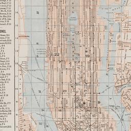
140. Map of New York
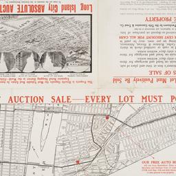
Trott, E. R
maps
- Name: Trott, E. R
- Published: Eugene R. Trott: New York. [191-?]
- Format: maps
- Catalog Record: check availability
141. Map of New York : places of interest and general information concerning the city
maps
- Published: [publisher not identified]: New York?. [1920?]
- Format: maps
- Online: click here for full-text
- Catalog Record: check availability

142. Map of New York : places of interest and general information concerning the city
Ohman Map Co
maps
- Name: Ohman Map Co
- Published: Aug. R. Ohman Map Co: New York. c1913
- Format: maps
- Online: click here for full-text
- Catalog Record: check availability

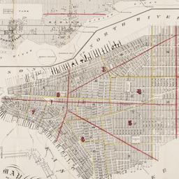
143. Map of New York and vicinity
Dripps, M
maps
- Name: Dripps, M
- Published: M. Dripps: N[ew] Y[ork]. c1865
- Format: maps
- Online: click here for full-text
- Catalog Record: check availability
144. Map of New York City
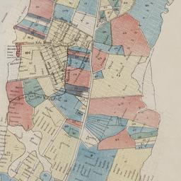
maps
- Published: Hunt & Eaton: New York?. c1891
- Format: maps
- Online: click here for full-text
- Catalog Record: check availability
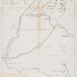
145. [Map of New York Harbor, New York Bay, and Staten Island]
maps
- Published: s.n: New York?. 18--?]
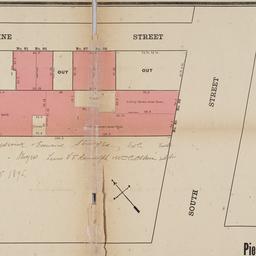
- Format: maps
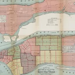
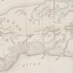
- Online: click here for full-text
- Catalog Record: check availability
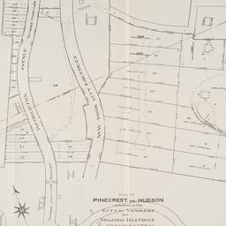
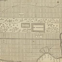
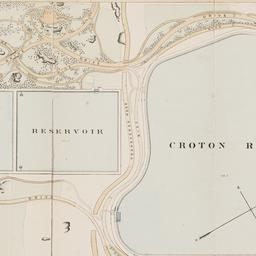
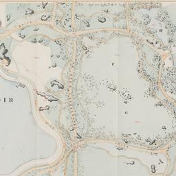
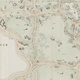
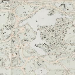
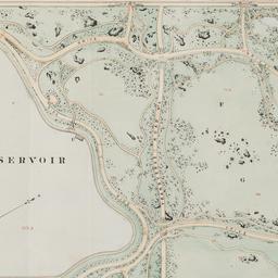
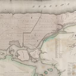
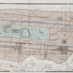
146. Map of Pinecrest-on-Hudson situated in the City of Yonkers and Village of Hastings Westchester Co
maps
- Published: s.n: New York?. 1907]
- Format: maps
- Online: click here for full-text
- Catalog Record: check availability
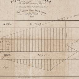
147. Map of property at Harlaem [sic] to be sold in one parcel on Tuesday the 3rd of February 1835 by James Bleecker & Sons at 11 o'clock
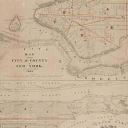
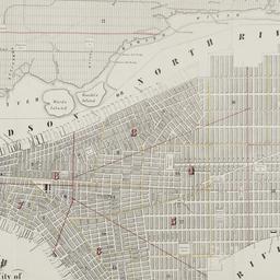
maps
- Published: P. Desobry's: New York. [1835]
- Format: maps
- Online: click here for full-text
- Catalog Record: check availability
148. Map of property belonging to the Courtney Development Company situate partly in the First and Second Wards, borough of Queens, city of New York
maps
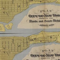
- Published: s.n: New York. 1913]
- Format: maps
- Online: click here for full-text
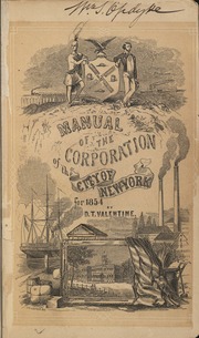
- Catalog Record: check availability
149. Map of Prospect Hill late the seat of Francis B. Winthrop, Esqr., in the Twelfth Ward in the city of New York
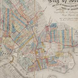
maps
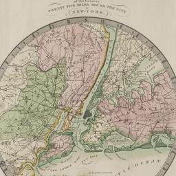
- Published: Lambert's Lithography: New York. [1879?]
- Format: maps
- Online: click here for full-text
- Catalog Record: check availability
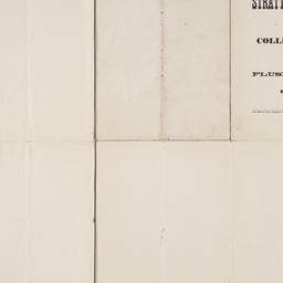
150. Map of Stratton Bluffs at College Point on Flushing Bay, New York
maps
- Published: John Meddle & Son: New York. [1891]
- Format: maps
- Online: click here for full-text
- Catalog Record: check availability
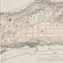
151. Map of that part of the city of New York north of 155th street : showing the progress made in laying out streets, roads, public squares and places, by the Commissioners of the Central Park, under Chap. 565 of Laws of 1865 and of new Pier and Bulkhead Laws under Chap. 697 of Laws of 1867
maps
- Published: Major & Knapp Eng. Mfg. & Lith. Co: N.Y. 1870
- Format: maps
- Online: click here for full-text
- Catalog Record: check availability
152. [Map of the area bounded by Broadway and St. Nicholas from West 190th Street to West 193rd Street]
maps
- Published: Martin B. Brown Co: New York. [1907]
- Format: maps
- Online: click here for full-text
- Catalog Record: check availability
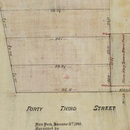
153. [Map of the area bounded by Forty Third Street and Broadway]
maps
- Published: [s.n.]: New York. 1880
- Format: maps
- Online: click here for full-text
- Catalog Record: check availability
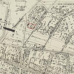
154. [Map of the area bounded by New Chambers Street, Peart Street, Beekman Street, and Nassau Street]
maps
- Published: s.n: New York?. 1914?]
- Format: maps
- Online: click here for full-text
- Catalog Record: check availability
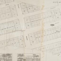
155. [Map of the area in Long Island City from Vernon Ave. to Meadow St. between Sixth St. and Fourteenth St.]
maps
- Published: August R. Ohman & Co: New York. [1908]
- Format: maps
- Online: click here for full-text
- Catalog Record: check availability
156. [Map of the area in Lower Manhattan bound by Pine Street, South Street, Wall Street and Front Street]
maps
- Published: s.n: New York?. 1895?]
- Format: maps
- Online: click here for full-text
- Catalog Record: check availability

157. Map of the bays, harbors, and rivers around New York : showing the channels, soundings, lighthouses, buoys &c., and the complete topography of the surrounding country : including Hempstead, Sandy-Hook, South-Amboy, Newark, Yonkers, N. Rochelle & Glen Cove
Bache, A. D. 1806-1867
maps
- Name: Bache, A. D. 1806-1867
- Published: M. Dripps: New York. [1866]
- Format: maps
- Catalog Record: check availability
158. Map of the boundaries of the Fire Department of the City of New York
New York (N.Y.). Fire Department
maps
- Name: New York (N.Y.). Fire Department
- Published: s.n.]: New York. 1871
- Format: maps
- Online: click here for full-text
- Catalog Record: check availability

159. Map of the Central Park : showing the progress of the work up to January 1st 1860
maps
- Published: Lith. by Sarony, Major & Knapp: New York, N.Y. [1860]
- Format: maps
- Online: click here for full-text
- Catalog Record: check availability
160. Map of the Central Park, New York
maps
- Published: Frank Leslie: New York?. 1856]
- Format: maps
- Online: click here for full-text
- Catalog Record: check availability
161. Map of the Central Park showing the progress of the work up to January 1st, 1863
maps
- Published: Sarony Major & Knapp: New York. [1863]
- Format: maps
- Online: click here for full-text
- Catalog Record: check availability
162. Map of the Central Park showing the progress of the work up to January 1st, 1864
maps
- Published: s.n: New York?. 1864]
- Format: maps
- Online: click here for full-text
- Catalog Record: check availability
163. Map of the Central Park showing the progress of the work up to January 1st, 1865
maps
- Published: s.n: New York?. 1865]
- Format: maps
- Online: click here for full-text
- Catalog Record: check availability
164. Map of the Central Park showing the progress of the work up to January 1st, 1866
maps
- Published: s.n: New York?. 1866]
- Format: maps
- Online: click here for full-text
- Catalog Record: check availability
165. Map of the Central Park showing the progress of the work up to January 1st 1867
maps
- Published: s.n: New York. 1867?]
- Format: maps
- Online: click here for full-text
- Catalog Record: check availability
166. Map of the city & county of New York
Hayward, George, approximately 1800-
maps
- Name: Hayward, George, approximately 1800-
- Published: Engraved for D.T. Valentine's manual for 1862, by Geo. Hayward: New York (N.Y.). [1861]
- Format: maps
- Online: click here for full-text
- Catalog Record: check availability
167. Map of the city and county of New York : with the adjacent country
Burr, David H., 1803-1875
maps
- Name: Burr, David H., 1803-1875
- Published: s.n: New York. 1829]
- Format: maps
- Online: click here for full-text
- Catalog Record: check availability
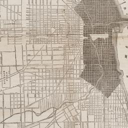
168. Map of the city of Chicago
maps
- Published: James Gordon Bennett: New York. 1871]
- Format: maps
- Online: click here for full-text
- Catalog Record: check availability

169. Map of the City of New York
W.C. Rogers & Co
maps
- Name: W.C. Rogers & Co
- Published: s.n.]: New York. 1868
- Format: maps
- Online: click here for full-text
- Catalog Record: check availability

170. Map of the City of New York : shewing the original high water ine and the location of the different farms and estates
Hayward, George, approximately 1800-
maps
- Name: Hayward, George, approximately 1800-
- Published: New York Common Council: New York. 1852]
- Format: maps
- Online: click here for full-text
- Catalog Record: check availability
171. Map of the City of New York, 1856
Hayward, George, approximately 1800-
maps
- Name: Hayward, George, approximately 1800-
- Published: New York Common Council: New York. 1856]
- Format: maps
- Online: click here for full-text
- Catalog Record: check availability
172. Map of the City of New York, from the Battery to 80th Street, showing the original topography of Manhattan Island
Viele, Egbert L. 1825-1902
maps
- Name: Viele, Egbert L. 1825-1902
- Published: s.n: New York. 1866?]
- Format: maps
- Online: click here for full-text
- Catalog Record: check availability
173. Map of the City of New York, showing its political divisions and subdivisions, August 1869
maps
- Published: s.n: New York?. 1869]
- Format: maps
- Catalog Record: check availability
174. Map of the city of New York showing the original high water lines and the location of the different farms and estates
Hayward, George, approximately 1800-
maps
- Name: Hayward, George, approximately 1800-
- Published: Common Council: New York. 1852]
- Format: maps
- Online: click here for full-text
- Catalog Record: check availability
175. Map of the city of New York showing the proposed route of the "arcade" underground railway
maps
- Published: G.W. & C.B. Colton: New York. [1870?]
- Format: maps
- Online: click here for full-text
- Catalog Record: check availability
176. Map of the City of New-York
Hayward, George, approximately 1800-
maps
- Name: Hayward, George, approximately 1800-
- Published: Common Council, 1854]: New York. 1854
- Format: maps
- Online: click here for full-text
- Catalog Record: check availability
177. Map of the city of New-York, 1853
Hayward, George, approximately 1800-
maps
- Name: Hayward, George, approximately 1800-
- Published: Common Council: New York, N.Y. 1853]
- Format: maps
- Online: click here for full-text
- Catalog Record: check availability
178. Map of the consolidated City of Brooklyn : comprising the City of Brooklyn, City of Williamsburgh and Town of Bushwick, Kings County, Long Island
Hayward, George, approximately 1800-
maps
- Name: Hayward, George, approximately 1800-
- Published: G. Hayward: New York. 1854
- Format: maps
- Online: click here for full-text
- Catalog Record: check availability
179. Map of the country twenty-five miles round the city of New-York
Burr, David H., 1803-1875
maps
- Name: Burr, David H., 1803-1875
- Published: David H. Burr: New York. 1831
- Format: maps
- Online: click here for full-text
- Catalog Record: check availability
180. Map of the Dell, Chester Hill City of Mount Vernon N.Y
maps
- Published: George W. Bard Real Estate Company: Mount Vernon, N.Y. [1907]
- Format: maps
- Online: click here for full-text
- Catalog Record: check availability