Search Results Header
Search Results

1. [Brooklyn Bridge pier and ferry]
ephemera
- Published: s.n: New York?. 1874?]
- Format: ephemera
- Catalog Record: check availability

2. Map of New York : places of interest and general information concerning the city
Ohman Map Co
maps
- Name: Ohman Map Co
- Published: Aug. R. Ohman Map Co: New York. c1913
- Format: maps
- Online: click here for full-text
- Catalog Record: check availability
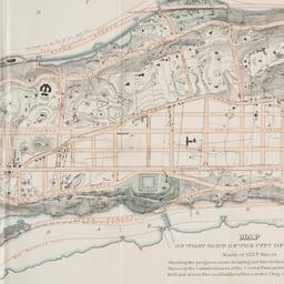
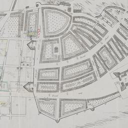
3. Map of that part of the city of New York north of 155th street : showing the progress made in laying out streets, roads, public squares and places, by the Commissioners of the Central Park, under Chap. 565 of Laws of 1865 and of new Pier and Bulkhead Laws under Chap. 697 of Laws of 1867
maps
- Published: Major & Knapp Eng. Mfg. & Lith. Co: N.Y. 1870
- Format: maps
- Online: click here for full-text
- Catalog Record: check availability
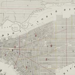
4. Map of the City of New-York
Hayward, George, approximately 1800-
maps
- Name: Hayward, George, approximately 1800-
- Published: Common Council, 1854]: New York. 1854
- Format: maps
- Online: click here for full-text
- Catalog Record: check availability
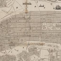
5. Map of the city of New-York, 1853
Hayward, George, approximately 1800-
maps
- Name: Hayward, George, approximately 1800-
- Published: Common Council: New York, N.Y. 1853]
- Format: maps
- Online: click here for full-text
- Catalog Record: check availability
6. New York city map
Phelps, Humphrey, active 19th century
maps
- Name: Phelps, Humphrey, active 19th century
- Published: H. Phelps: New York. c1857
- Format: maps
- Online: click here for full-text
- Catalog Record: check availability
7. New Yorke, 1695
Miller, John, 1666-1724
maps
- Name: Miller, John, 1666-1724
- Published: Lith. G. Hayward: New York. [1852]
- Format: maps
- Online: click here for full-text
- Catalog Record: check availability

8. One day's trucking to and from the New York Central's pier and inland stations south of Fifty-Ninth Street
maps
- Published: J.B. Lyon Co: Albany. 1920]
- Format: maps
- Online: click here for full-text
- Catalog Record: check availability
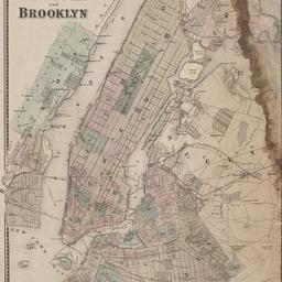
9. Plan of New York and Brooklyn
maps
- Published: s.n: S.l. 186-?]
- Format: maps
- Online: click here for full-text
- Catalog Record: check availability
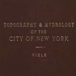
10. Topographical map of the City of New York showing original water courses and made land
Viele, Egbert L. 1825-1902
maps
- Name: Viele, Egbert L. 1825-1902
- Published: Ferd. Mayer & Co. lith: New York. c1865
- Format: maps
- Catalog Record: check availability
Search Other Sources for: "Piers"
Try your search in one of these related resources. (Search results will display in a new window.)
-
Avery Index to Architectural Periodicals
A comprehensive listing of journal articles published worldwide on architecture and design, archaeology, city planning, interior design, landscape architecture, and historic preservation. -
Brooklyn Historical Society Photography Collection
Search for individual photographs. Approximately 5,000 of our images are currently available online, but more images are added regularly. -
Brooklyn Public Library: Historic Brooklyn Photographs
Selection of more than ten thousand historic photographs from the Brooklyn Collection. -
CLIO: Columbia Libraries Catalog
Search for books, articles, journals, online resources and more. -
DLC: Columbia Libraries Digital Collections
A gateway to digital projects and online exhibitions that have been published on the web by Columbia University Libraries/Information Services (CUL/IS). -
Museum of the City of New York
Over 150,000 images and objects from the collections of the Museum of the City of New York.
Note: to come. -
New York Historical Society
Digital images from the library and museum collections. -
NYPL Digital Collections
Provides free and open access to over 800,000 images digitized from the The New York Public Library's vast collections.