Search Results Header
Search Results
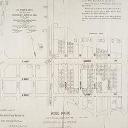
1. Adee Park east of Botanical Garden, Bronx Park : Borough of the Bronx, New York City
maps
- Published: s.n: New York?. 1906]
- Format: maps
- Online: click here for full-text
- Catalog Record: check availability
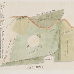
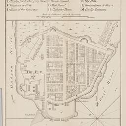
2. At the request of the recorder Thomas Jones Esqr. chairman, & the other gentlemen of the committee, I have surveyed the farm commonly called Tuttle Bay, granted by William Keist 23d of April 1646. unto George Holmes & Thomas Hall, and find the same to be agreeable to the above draft
Maerschalck, Francis W., -1776
maps
- Name: Maerschalck, Francis W., -1776
- Published: Common Council?: New York?. 1860?]
- Format: maps
- Online: click here for full-text
- Catalog Record: check availability
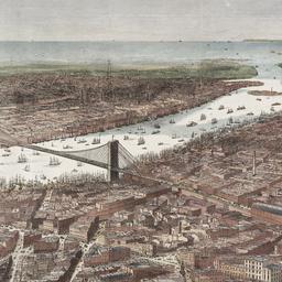
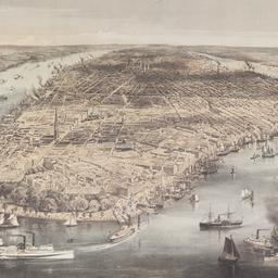
3. Bird's-eye view of the southern end of New York and Brooklyn, showing the projected suspension-bridge over the East River, from the western terminus in Printing-House Square, New York
Davis, Theodore R
maps
- Name: Davis, Theodore R
- Published: New York. 1870]
- Format: maps
- Online: click here for full-text
- Catalog Record: check availability
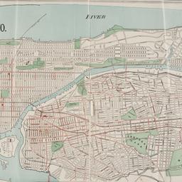
4. Boroughs of Manhattan and the Bronx showing the electric service of the New York Edison Co
maps
- Published: Bormay & Co: New York. [1902?]
- Format: maps
- Online: click here for full-text
- Catalog Record: check availability
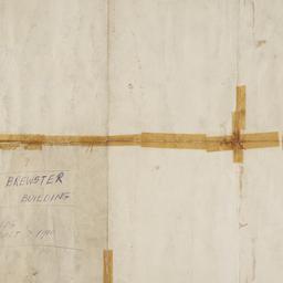
5. Brewster & Company, Inc. (Bldg.) Rolls-Royce of America, Inc. (Ten.) (Garage) Long Island City New York
Associated Factory Mutual Fire Insurances Companies
maps
- Name: Associated Factory Mutual Fire Insurances Companies
- Published: Associated Factory Fire Insurance Companies: Boston, Mass. [1932]
- Format: maps
- Online: click here for full-text
- Catalog Record: check availability
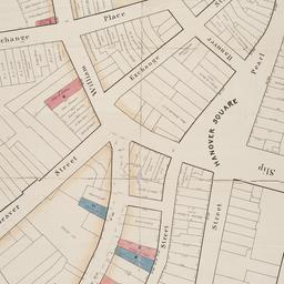
6. [Broad Street to Water Street south of Wall Street]
maps
- Published: s.n: New York?. 18--?]
- Format: maps
- Online: click here for full-text
- Catalog Record: check availability
7. Brooklyn
maps
- Published: E.F. Fisk: New York. [1890?]
- Format: maps
- Online: click here for full-text
- Catalog Record: check availability
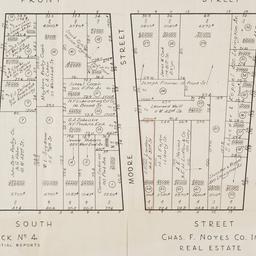
8. [Cadastral map of the area bound by South Street and Front Street between Whitehall Street and Broad Street]
maps
- Published: Chas. F. Noyes Co: New York. 1931?]
- Format: maps
- Online: click here for full-text
- Catalog Record: check availability
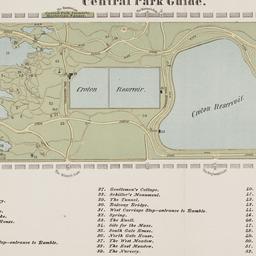
9. Central Park guide
maps
- Published: s.n: New York?. 1868?]
- Format: maps
- Online: click here for full-text
- Catalog Record: check availability
10. City of Manhattan or New York
Bellin, Jacques Nicolas, 1703-1772
maps
- Name: Bellin, Jacques Nicolas, 1703-1772
- Published: Common Council: New York. 1861]
- Format: maps
- Online: click here for full-text
- Catalog Record: check availability
11. City of New York
Parsons, Charles, 1821-1910
maps
- Name: Parsons, Charles, 1821-1910
- Published: N. Currier: New York. 1856
- Format: maps
- Online: click here for full-text
- Catalog Record: check availability
12. City of New-York
Burr, David H., 1803-1875
maps
- Name: Burr, David H., 1803-1875
- Published: Republished by W.P. Stone: Ithaca, N.Y. 1838
- Format: maps
- Online: click here for full-text
- Catalog Record: check availability
13. Colton's map of the cities of New York, Brooklyn, Jersey City, Hoboken, etc
maps
- Published: G.W. & C.B. Colton & Co: New York. c1886
- Format: maps
- Online: click here for full-text
- Catalog Record: check availability
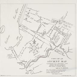
14. Copy of an ancient map in possession of a descendant of the Hannes or Han Bergen : whose house is located thereon
Bergen, Teunis G., 1806-1881
maps
- Name: Bergen, Teunis G., 1806-1881
- Published: Henry McCloskey?: N.Y.?. 1864]
- Format: maps
- Online: click here for full-text
- Catalog Record: check availability
15. C.W. Hobbs' guide map of New York City
Hobbs, C. W
maps
- Name: Hobbs, C. W
- Published: C.W. Hobbs: New York?. [between 1864 and 1884]
- Format: maps
- Online: click here for full-text
- Catalog Record: check availability
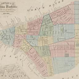
16. D. Devlin & Co., clothing warehouse
D. Devlin & Co
maps
- Name: D. Devlin & Co
- Published: James Mowlem & Co: N[ew] Y[ork]. [185-]
- Format: maps
- Online: click here for full-text
- Catalog Record: check availability
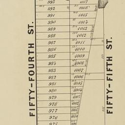
17. Extensive sale of lots of land located on Broadway, 7th 8th 9th, 10th and 11th Avenues and on 50th, 51st, 52d, 53d, and 54th Streets by order of the Supreme Court : under the direction of Philo. T. Ruggles, referee : Wednesday, June 18th, 1856, at 12 o'clock at the Merchants' Exchange
maps
- Published: Francis & Loutrel: New York?. [1856]
- Format: maps
- Online: click here for full-text
- Catalog Record: check availability
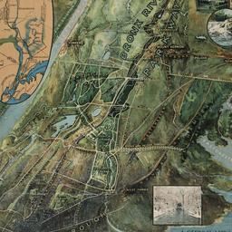
18. A general view of the Bronx River Parkway Reservation : as a connecting parkway between the park system of New York City, the Croton and Catskill watersheds, and the Harriman and Palisades Interstate Parks
New York (State). Bronx Parkway Commission
maps
- Name: New York (State). Bronx Parkway Commission
- Published: Bronx Parkway Commission: New York. 1915
- Format: maps
- Online: click here for full-text
- Catalog Record: check availability
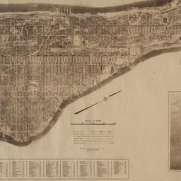
19. The Hamilton aerial map of Manhattan, New York City
Hamilton, W. L
maps
- Name: Hamilton, W. L
- Published: Hamilton Aeriel Maps: New York. c1928
- Format: maps
- Online: click here for full-text
- Catalog Record: check availability
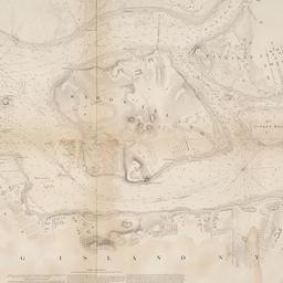
20. Hell Gate and its approaches
United States Coast Survey
maps
- Name: United States Coast Survey
- Published: U.S. Coast Survey: Washington. 1853
- Format: maps
- Online: click here for full-text
- Catalog Record: check availability

21. Hunters Point, part of Long Island City
maps
- Published: Beers, Comstock & Cline: N.Y. 1873]
- Format: maps
- Online: click here for full-text click here for full-text
- Catalog Record: check availability
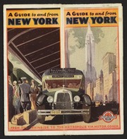
22. Into the heart of New York City by train & motor coach
Rand McNally and Company
maps
- Name: Rand McNally and Company
- Published: Rand McNally and Co: New York. [1933]
- Format: maps
- Online: click here for full-text
- Catalog Record: check availability
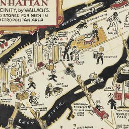
23. A man's map of Manhattan and vicinity by Wallach's
Voorhies, Stephen J
maps
- Name: Voorhies, Stephen J
- Format: maps
- Catalog Record: check availability
24. A man's map of New York by Wallach's
Voorhies, Stephen J
maps
- Name: Voorhies, Stephen J
- Format: maps
- Catalog Record: check availability
Search Other Sources for: "Architecture"
Try your search in one of these related resources. (Search results will display in a new window.)
-
Avery Index to Architectural Periodicals
A comprehensive listing of journal articles published worldwide on architecture and design, archaeology, city planning, interior design, landscape architecture, and historic preservation. -
Brooklyn Historical Society Photography Collection
Search for individual photographs. Approximately 5,000 of our images are currently available online, but more images are added regularly. -
Brooklyn Public Library: Historic Brooklyn Photographs
Selection of more than ten thousand historic photographs from the Brooklyn Collection. -
CLIO: Columbia Libraries Catalog
Search for books, articles, journals, online resources and more. -
DLC: Columbia Libraries Digital Collections
A gateway to digital projects and online exhibitions that have been published on the web by Columbia University Libraries/Information Services (CUL/IS). -
Museum of the City of New York
Over 150,000 images and objects from the collections of the Museum of the City of New York.
Note: to come. -
New York Historical Society
Digital images from the library and museum collections. -
NYPL Digital Collections
Provides free and open access to over 800,000 images digitized from the The New York Public Library's vast collections.