Search Results Header
Search Results

1. "21" [matchcover from the 21 Club, without matches]
21 (Restaurant : New York, N.Y.)
objects
- Name: 21 (Restaurant : New York, N.Y.)
- Published: Universal Match: New York. [198u?]
- Format: objects
- Catalog Record: check availability
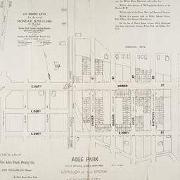
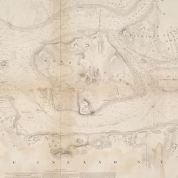
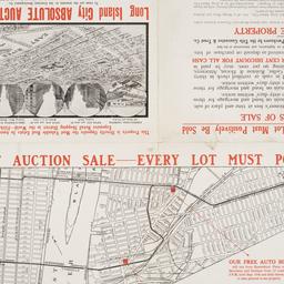
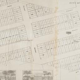
2. Adee Park east of Botanical Garden, Bronx Park : Borough of the Bronx, New York City
maps
- Published: s.n: New York?. 1906]
- Format: maps
- Online: click here for full-text
- Catalog Record: check availability
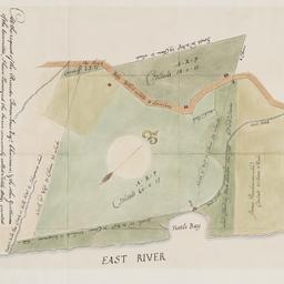
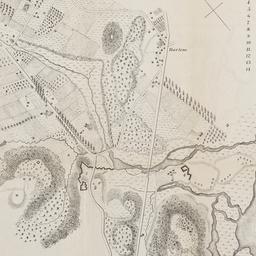
3. At the request of the recorder Thomas Jones Esqr. chairman, & the other gentlemen of the committee, I have surveyed the farm commonly called Tuttle Bay, granted by William Keist 23d of April 1646. unto George Holmes & Thomas Hall, and find the same to be agreeable to the above draft
Maerschalck, Francis W., -1776
maps
- Name: Maerschalck, Francis W., -1776
- Published: Common Council?: New York?. 1860?]
- Format: maps
- Online: click here for full-text
- Catalog Record: check availability
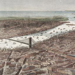
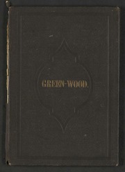
4. Bird's-eye view of the southern end of New York and Brooklyn, showing the projected suspension-bridge over the East River, from the western terminus in Printing-House Square, New York
Davis, Theodore R
maps
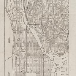
- Name: Davis, Theodore R
- Published: New York. 1870]
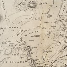
- Format: maps
- Online: click here for full-text
- Catalog Record: check availability
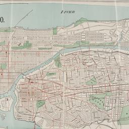
5. Boroughs of Manhattan and the Bronx showing the electric service of the New York Edison Co
maps
- Published: Bormay & Co: New York. [1902?]
- Format: maps
- Online: click here for full-text
- Catalog Record: check availability
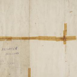
6. Brewster & Company, Inc. (Bldg.) Rolls-Royce of America, Inc. (Ten.) (Garage) Long Island City New York
Associated Factory Mutual Fire Insurances Companies
maps
- Name: Associated Factory Mutual Fire Insurances Companies
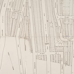
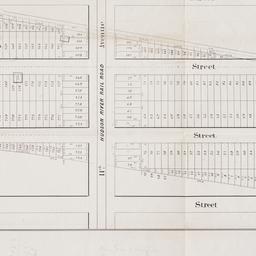
- Published: Associated Factory Fire Insurance Companies: Boston, Mass. [1932]
- Format: maps
- Online: click here for full-text
- Catalog Record: check availability
7. [Broad Street to Water Street south of Wall Street]
maps
- Published: s.n: New York?. 18--?]
- Format: maps
- Online: click here for full-text
- Catalog Record: check availability
8. Brooklyn
maps
- Published: E.F. Fisk: New York. [1890?]
- Format: maps
- Online: click here for full-text
- Catalog Record: check availability
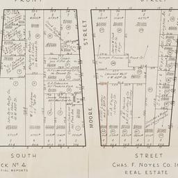
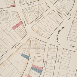
9. [Cadastral map of the area bound by South Street and Front Street between Whitehall Street and Broad Street]
maps
- Published: Chas. F. Noyes Co: New York. 1931?]
- Format: maps
- Online: click here for full-text
- Catalog Record: check availability
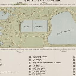
10. Central Park guide
maps
- Published: s.n: New York?. 1868?]
- Format: maps
- Online: click here for full-text
- Catalog Record: check availability
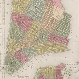
11. City of Manhattan or New York
Bellin, Jacques Nicolas, 1703-1772
maps
- Name: Bellin, Jacques Nicolas, 1703-1772
- Published: Common Council: New York. 1861]
- Format: maps
- Online: click here for full-text
- Catalog Record: check availability
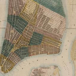
12. City of New York
Parsons, Charles, 1821-1910
maps
- Name: Parsons, Charles, 1821-1910
- Published: N. Currier: New York. 1856
- Format: maps
- Online: click here for full-text
- Catalog Record: check availability
13. The city of New York
Williams, J. W., active 1879
maps
- Name: Williams, J. W., active 1879
- Published: New York. ©1879
- Format: maps
- Online: click here for full-text
- Catalog Record: check availability
14. City of New York
Thomas, Cowperthwait & Co
maps
- Name: Thomas, Cowperthwait & Co
- Published: s.n.]: Philadelphia, Pa.?. 1850
- Format: maps
- Online: click here for full-text
- Catalog Record: check availability
15. City of New-York
Burr, David H., 1803-1875
maps
- Name: Burr, David H., 1803-1875
- Published: Republished by W.P. Stone: Ithaca, N.Y. 1838
- Format: maps
- Online: click here for full-text
- Catalog Record: check availability
16. Colton's map of the cities of New York, Brooklyn, Jersey City, Hoboken, etc
maps
- Published: G.W. & C.B. Colton & Co: New York. c1886
- Format: maps
- Online: click here for full-text
- Catalog Record: check availability
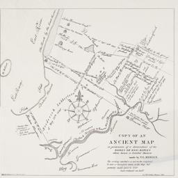
17. Copy of an ancient map in possession of a descendant of the Hannes or Han Bergen : whose house is located thereon
Bergen, Teunis G., 1806-1881
maps
- Name: Bergen, Teunis G., 1806-1881
- Published: Henry McCloskey?: N.Y.?. 1864]
- Format: maps
- Online: click here for full-text
- Catalog Record: check availability
18. C.W. Hobbs' guide map of New York City
Hobbs, C. W
maps
- Name: Hobbs, C. W
- Published: C.W. Hobbs: New York?. [between 1864 and 1884]
- Format: maps
- Online: click here for full-text
- Catalog Record: check availability
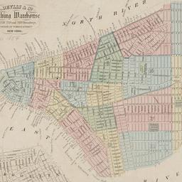
19. D. Devlin & Co., clothing warehouse
D. Devlin & Co
maps
- Name: D. Devlin & Co
- Published: James Mowlem & Co: N[ew] Y[ork]. [185-]
- Format: maps
- Online: click here for full-text
- Catalog Record: check availability
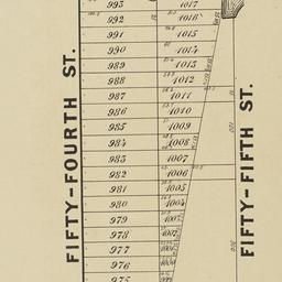
20. Extensive sale of lots of land located on Broadway, 7th 8th 9th, 10th and 11th Avenues and on 50th, 51st, 52d, 53d, and 54th Streets by order of the Supreme Court : under the direction of Philo. T. Ruggles, referee : Wednesday, June 18th, 1856, at 12 o'clock at the Merchants' Exchange
maps
- Published: Francis & Loutrel: New York?. [1856]
- Format: maps
- Online: click here for full-text
- Catalog Record: check availability
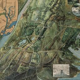
21. A general view of the Bronx River Parkway Reservation : as a connecting parkway between the park system of New York City, the Croton and Catskill watersheds, and the Harriman and Palisades Interstate Parks
New York (State). Bronx Parkway Commission
maps
- Name: New York (State). Bronx Parkway Commission
- Published: Bronx Parkway Commission: New York. 1915
- Format: maps
- Online: click here for full-text
- Catalog Record: check availability
22. Green Wood Cemetery
maps
- Published: s.n.]: S.l. 1869
- Format: maps
- Online: click here for full-text
- Catalog Record: check availability

23. Green-wood cemetery
maps
- Published: s.n.]: S.l. 1890
- Format: maps
- Online: click here for full-text
- Catalog Record: check availability

24. Green-Wood Cemetery
maps
- Published: s.n.]: New York?. 1887
- Format: maps
- Online: click here for full-text
- Catalog Record: check availability
25. The Hamilton aerial map of Manhattan, New York City
Hamilton, W. L
maps
- Name: Hamilton, W. L
- Published: Hamilton Aeriel Maps: New York. c1928
- Format: maps
- Online: click here for full-text
- Catalog Record: check availability
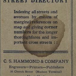
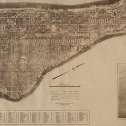
26. Hammond's new guide map of Manhattan and the Bronx
C.S. Hammond & Company
maps
- Name: C.S. Hammond & Company
- Published: C.S. Hammond & Co: New York. [between 1900 and 1930]
- Format: maps
- Catalog Record: check availability
27. Hammond's new guide map of Manhattan and the Bronx
C.S. Hammond & Company
maps
- Name: C.S. Hammond & Company
- Published: C.S. Hammond: New York. [1910] c1908
- Format: maps
- Catalog Record: check availability
28. Hell Gate and its approaches
United States Coast Survey
maps
- Name: United States Coast Survey
- Published: U.S. Coast Survey: Washington. 1853
- Format: maps
- Online: click here for full-text
- Catalog Record: check availability

29. Hotel Astor, New York
objects
- Published: s.n: New York?. between 1904 and 1967]
- Format: objects
- Catalog Record: check availability
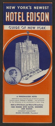
30. Hotel Edison, New York : part of Bronx and Queens showing World's Fair, indexed, house number map
Nostrand, George J
maps
- Name: Nostrand, George J
- Published: Hotel Edison?: New York?. 1939?]
- Format: maps
- Online: click here for full-text
- Catalog Record: check availability

31. Hunters Point, part of Long Island City
maps
- Published: Beers, Comstock & Cline: N.Y. 1873]
- Format: maps
- Online: click here for full-text click here for full-text
- Catalog Record: check availability
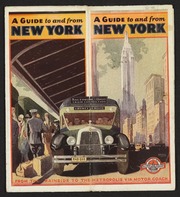
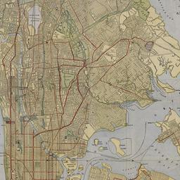
32. Into the heart of New York City by train & motor coach
Rand McNally and Company
maps
- Name: Rand McNally and Company
- Published: Rand McNally and Co: New York. [1933]
- Format: maps
- Online: click here for full-text
- Catalog Record: check availability
33. [Letterhead stationery with views of New York City hotels]
manuscripts
- Published: s. n: New York. between 1849 and 1930?]
- Format: manuscripts
- Catalog Record: check availability
34. The Lincoln Building, 60 E. 42nd St. NYC
objects
- Published: Helmsley-Spear Inc: New York, N.Y. [1987]
- Format: objects
- Catalog Record: check availability
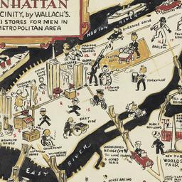
35. A man's map of Manhattan and vicinity by Wallach's
Voorhies, Stephen J
maps
- Name: Voorhies, Stephen J
- Format: maps
- Catalog Record: check availability
36. A man's map of New York by Wallach's
Voorhies, Stephen J
maps
- Name: Voorhies, Stephen J
- Format: maps
- Catalog Record: check availability
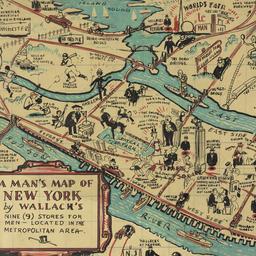
37. A man's map of New York by Wallach's
Voorhies, Stephen J
maps
- Name: Voorhies, Stephen J
- Format: maps
- Catalog Record: check availability
38. Map & plan of the proposed continuation of the widening & extension of William Street : from Maiden Lane to Chatham Street & the new line of said strt. as adopted between Wall St. & Maiden Lane, showing the situation of the property advertised by John R. Pitkin (No. 5 Broad Strt.)
maps
- Published: [publisher not identified]: N.Y.?. [183-?
- Format: maps
- Online: click here for full-text
- Catalog Record: check availability
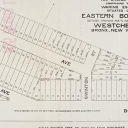
39. Map of 105 choice lots comprising the Waring Estate situated on Eastern Boulevard between Tremont Ave and Fort Schuyler Road Westchester Bronx, New York City
maps
- Published: s.n: New York. 1906]
- Format: maps
- Online: click here for full-text
- Catalog Record: check availability

40. Map of 158 building lots at Harlaem [sic] to be sold by James Bleeckeer & Sons on Wednesday January 15th at 12 o'clock at the Merchts Exchange
maps
- Published: P. Desbroy's: New York. [18--?]
- Format: maps
- Online: click here for full-text
- Catalog Record: check availability
41. Map of 500 lots of the estate of James Cordon Bennett, dec'd, located between Broadway and N.Y. Central and Hudson River, RR. and between W. 181st and W. 187th Streets borough of Manhattan City of New York
maps
- Published: s.n: New York. 1919]
- Format: maps
- Online: click here for full-text
- Catalog Record: check availability
42. [Map of 50th Street to 53rd Street between 10th Avenue and 13th Avenue]
maps
- Published: s.n: New York?. 1851?]
- Format: maps
- Online: click here for full-text
- Catalog Record: check availability

43. Map of 58 lots belonging to the Griswold Estate fronting on the continuation of Riverside Drive known as Fieldston Road and situated between Broadway and Riverdale Avenue, W. 246th Street and W. 253rd Street
maps
- Published: s.n: New. 1910]
- Format: maps
- Online: click here for full-text
- Catalog Record: check availability
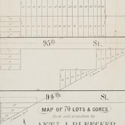
44. Map of 70 lots & gores to be sold at auction by Aty J. Bleecker on Monday 25th March 1850 at 12 o'clock at the Merchants Exchange
maps
- Published: Serrell & Perkins: New York. [1850]
- Format: maps
- Online: click here for full-text
- Catalog Record: check availability

45. Map of 80 acres of land situate in the 12th Ward of the city of New York part of the estate of Isaac Dyckman, dec'd : known as the "Part 3rd of the Dyckman Homestead Property" to be sold by V.K. Stevenson Son & Co, B.P. Fairchild, Auctioneer, June 7th, 1871 at the Exchange Salesrooms, 111 Broadway, New York
maps
- Published: Major & Knapp Eng. Mfg. & Lith. Co: New York. [1871]
- Format: maps
- Online: click here for full-text
- Catalog Record: check availability
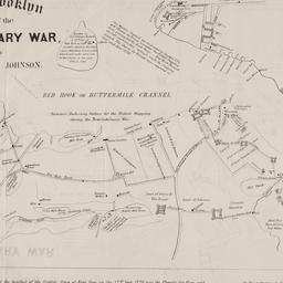
46. Map of Brooklyn at the time of the Revolutionary War
Johnson, Jeremiah, 1768-1852
maps
- Name: Johnson, Jeremiah, 1768-1852
- Published: George Hayward: N[ew] Y[ork]. [1858]
- Format: maps
- Online: click here for full-text
- Catalog Record: check availability
47. Map of Harlem Heights and plain, 1814
maps
- Published: [publisher not identified]: Place of publication not identified. [1856?]
- Format: maps
- Catalog Record: check availability
48. Map of land of Theodorus Bergen west of Third Avenue in the Eighth Ward of the city of Brooklyn : as surveyed December 1853 by T.G. Bergen
Bergen, Teunis G., 1806-1881
maps
- Name: Bergen, Teunis G., 1806-1881
- Format: maps
- Catalog Record: check availability
49. [Map of Manhattan, Brooklyn, Staten Island, Long Island, and New Jersey with references to the Battle on Long Island]
maps
- Published: s.n: New York?. 18--?]
- Format: maps
- Online: click here for full-text
- Catalog Record: check availability
50. Map of New York
Trott, E. R
maps
- Name: Trott, E. R
- Published: Eugene R. Trott: New York. [191-?]
- Format: maps
- Catalog Record: check availability
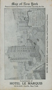
51. Map of New York : places of interest and general information concerning the city
maps
- Published: [publisher not identified]: New York?. [1920?]
- Format: maps
- Online: click here for full-text
- Catalog Record: check availability

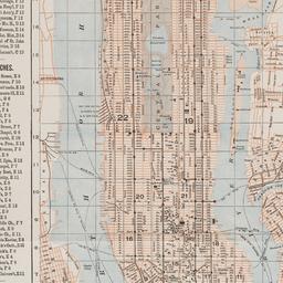
52. Map of New York : places of interest and general information concerning the city
Ohman Map Co
maps
- Name: Ohman Map Co
- Published: Aug. R. Ohman Map Co: New York. c1913
- Format: maps
- Online: click here for full-text
- Catalog Record: check availability

53. Map of New York and vicinity
Dripps, M
maps
- Name: Dripps, M
- Published: M. Dripps: N[ew] Y[ork]. c1865
- Format: maps
- Online: click here for full-text
- Catalog Record: check availability
54. Map of New York City
maps
- Published: Hunt & Eaton: New York?. c1891
- Format: maps
- Online: click here for full-text
- Catalog Record: check availability
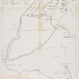
55. [Map of New York Harbor, New York Bay, and Staten Island]
maps
- Published: s.n: New York?. 18--?]
- Format: maps
- Online: click here for full-text
- Catalog Record: check availability
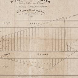
56. Map of property at Harlaem [sic] to be sold in one parcel on Tuesday the 3rd of February 1835 by James Bleecker & Sons at 11 o'clock
maps
- Published: P. Desobry's: New York. [1835]
- Format: maps
- Online: click here for full-text
- Catalog Record: check availability
57. Map of property belonging to the Courtney Development Company situate partly in the First and Second Wards, borough of Queens, city of New York
maps
- Published: s.n: New York. 1913]
- Format: maps
- Online: click here for full-text
- Catalog Record: check availability
58. Map of Prospect Hill late the seat of Francis B. Winthrop, Esqr., in the Twelfth Ward in the city of New York
maps
- Published: Lambert's Lithography: New York. [1879?]
- Format: maps
- Online: click here for full-text
- Catalog Record: check availability
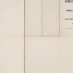
59. Map of Stratton Bluffs at College Point on Flushing Bay, New York
maps
- Published: John Meddle & Son: New York. [1891]
- Format: maps
- Online: click here for full-text
- Catalog Record: check availability
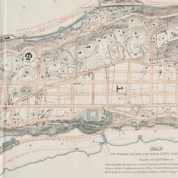
60. Map of that part of the city of New York north of 155th street : showing the progress made in laying out streets, roads, public squares and places, by the Commissioners of the Central Park, under Chap. 565 of Laws of 1865 and of new Pier and Bulkhead Laws under Chap. 697 of Laws of 1867
maps
- Published: Major & Knapp Eng. Mfg. & Lith. Co: N.Y. 1870
- Format: maps
- Online: click here for full-text
- Catalog Record: check availability