Search Results Header
Search Results
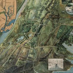
1. A general view of the Bronx River Parkway Reservation : as a connecting parkway between the park system of New York City, the Croton and Catskill watersheds, and the Harriman and Palisades Interstate Parks
New York (State). Bronx Parkway Commission
maps
- Name: New York (State). Bronx Parkway Commission
- Published: Bronx Parkway Commission: New York. 1915
- Format: maps
- Online: click here for full-text
- Catalog Record: check availability

2. Map of the City of New York
W.C. Rogers & Co
maps
- Name: W.C. Rogers & Co
- Published: s.n.]: New York. 1868
- Format: maps
- Online: click here for full-text
- Catalog Record: check availability

3. The new parks beyond the Harlem. With thirty illustrations and map. Descriptions of scenery. Nearly 4,000 acres of free playground for the people
Mullaly, John
books
- Name: Mullaly, John
- Published: Record & guide: New York. 1887
- Format: books
- Online: click here for full-text
- Catalog Record: check availability

4. Report to the New York Legislature of the Commission to Select and Locate Lands for Public Parks in the Twenty-third and Twenty-fourth Wards of the City of New York, and in the vicinity thereof. : According to the provisions of the act of the Legislature of the State of New York, chapter 253, passed April 19, 1883
New York (State). Commission to Select and Locate Lands for Public Parks in the Twenty-third and Twenty-fourth Wards of the City of New York
books
- Name: New York (State). Commission to Select and Locate Lands for Public Parks in the Twenty-third and Twenty-fourth Wards of the City of New York
- Published: M. B. Brown, printer: New York. 1884
- Format: books
- Online: click here for full-text
- Catalog Record: check availability