Search Results Header
Search Results
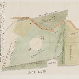
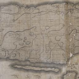
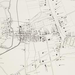
1. At the request of the recorder Thomas Jones Esqr. chairman, & the other gentlemen of the committee, I have surveyed the farm commonly called Tuttle Bay, granted by William Keist 23d of April 1646. unto George Holmes & Thomas Hall, and find the same to be agreeable to the above draft
Maerschalck, Francis W., -1776
maps
- Name: Maerschalck, Francis W., -1776
- Published: Common Council?: New York?. 1860?]
- Format: maps
- Online: click here for full-text
- Catalog Record: check availability
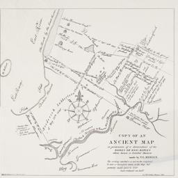
2. Copy of an ancient map in possession of a descendant of the Hannes or Han Bergen : whose house is located thereon
Bergen, Teunis G., 1806-1881
maps
- Name: Bergen, Teunis G., 1806-1881
- Published: Henry McCloskey?: N.Y.?. 1864]
- Format: maps
- Online: click here for full-text
- Catalog Record: check availability
3. [Deed for land in Windor Terrace, Brooklyn]
Riegel, George
books
- Name: Riegel, George
- Format: books
- Online: click here for full-text
- Catalog Record: check availability

4. Hunters Point, part of Long Island City
maps
- Published: Beers, Comstock & Cline: N.Y. 1873]
- Format: maps
- Online: click here for full-text click here for full-text
- Catalog Record: check availability

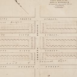
5. [Lease of ten lots on Broadway, Fourth Avenue and Thirteenth Street in Manhattan]
Astor, William B. 1792-1875
books
- Name: Astor, William B. 1792-1875
- Format: books
- Online: click here for full-text
- Catalog Record: check availability
6. Map & plan of the proposed continuation of the widening & extension of William Street : from Maiden Lane to Chatham Street & the new line of said strt. as adopted between Wall St. & Maiden Lane, showing the situation of the property advertised by John R. Pitkin (No. 5 Broad Strt.)
maps
- Published: [publisher not identified]: N.Y.?. [183-?
- Format: maps
- Online: click here for full-text
- Catalog Record: check availability
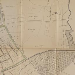
7. Map of land of Theodorus Bergen west of Third Avenue in the Eighth Ward of the city of Brooklyn : as surveyed December 1853 by T.G. Bergen
Bergen, Teunis G., 1806-1881
maps
- Name: Bergen, Teunis G., 1806-1881
- Format: maps
- Catalog Record: check availability
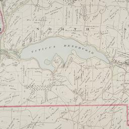
8. Map of Mount Vernon and environs, Westchester Co., N.Y. : showing lot numbers, subdivisions of lots and property lines, also location of sewers, gas and water mains
Goldthwaite, Wm. M
maps
- Name: Goldthwaite, Wm. M
- Published: Wm. M. Goldthwaite: New York, N.Y. 1890
- Format: maps
- Catalog Record: check availability

9. Map of the City of New York
W.C. Rogers & Co
maps
- Name: W.C. Rogers & Co
- Published: s.n.]: New York. 1868
- Format: maps
- Online: click here for full-text
- Catalog Record: check availability
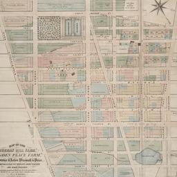
10. Map of the "Murray Hill Farm," "Ogden Place Farm," Lawrence & Astor, Wiswall & Price, Corporation, Wm. Wright, John Taylor and other property
Holmes, J. B
maps
- Name: Holmes, J. B
- Published: City Surveyor: New York. 1867]
- Format: maps
- Online: click here for full-text
- Catalog Record: check availability

11. Map shewing a division of part of the real estate late of Nicholas W. Stuyvesant decd. among his heirs situated in the 11th Ward of the City of New York
Doughty, Saml. S
maps
- Name: Doughty, Saml. S
- Published: Miller & Co. Lithog: New York. 1834 May
- Format: maps
- Online: click here for full-text
- Catalog Record: check availability
12. New-York City, County and vicinity
Dripps, M
maps
- Name: Dripps, M
- Published: s.n: New York?. 1866]
- Format: maps
- Online: click here for full-text
- Catalog Record: check availability
13. This map of the city of New York and island of Manhattan, as laid out by the commissioners appointed by the legislature, April 3d, 1807 is respectfully dedicated to the mayor, aldermen and commonalty thereof
Bridges, William, -1814
maps
- Name: Bridges, William, -1814
- Published: s.n.]: New York. 1811
- Format: maps
- Online: click here for full-text
- Catalog Record: check availability
14. Town of North Salem and part of the town of Lewisboro
maps
- Published: G.W. Bromley & Co: Philadelphia. 1910]
- Format: maps
- Online: click here for full-text
- Catalog Record: check availability
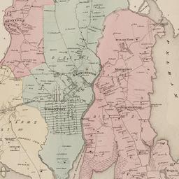
15. Town of Westchester, Westchester Co., N.Y
maps
- Published: F.W. Beers: New York. 186-]
- Format: maps
- Online: click here for full-text click here for full-text
- Catalog Record: check availability
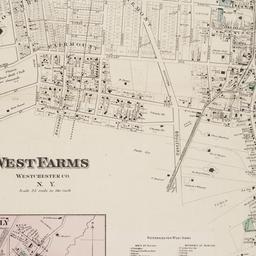
16. West Farms, Westchester Co., N.Y
Beers, F. W
maps
- Name: Beers, F. W
- Published: F.W. Beers: New York. 1868?]
- Format: maps
- Online: click here for full-text
- Catalog Record: check availability
17. White Plains, Westchester Co., N.Y
maps
- Published: Harbor Hill Books: Harrison, N.Y. [19--?]
- Format: maps
- Online: click here for full-text
- Catalog Record: check availability