Search Results Header
Search Results
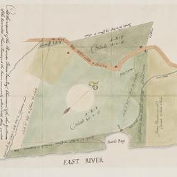
1. At the request of the recorder Thomas Jones Esqr. chairman, & the other gentlemen of the committee, I have surveyed the farm commonly called Tuttle Bay, granted by William Keist 23d of April 1646. unto George Holmes & Thomas Hall, and find the same to be agreeable to the above draft
Maerschalck, Francis W., -1776
maps
- Name: Maerschalck, Francis W., -1776
- Published: Common Council?: New York?. 1860?]
- Format: maps
- Online: click here for full-text
- Catalog Record: check availability
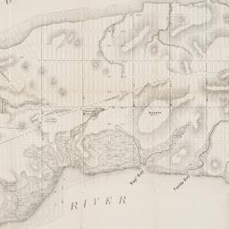
2. Map of the City of New York, from the Battery to 80th Street, showing the original topography of Manhattan Island
Viele, Egbert L. 1825-1902
maps
- Name: Viele, Egbert L. 1825-1902
- Published: s.n: New York. 1866?]
- Format: maps
- Online: click here for full-text
- Catalog Record: check availability
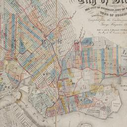
3. Map of the consolidated City of Brooklyn : comprising the City of Brooklyn, City of Williamsburgh and Town of Bushwick, Kings County, Long Island
Hayward, George, approximately 1800-
maps
- Name: Hayward, George, approximately 1800-
- Published: G. Hayward: New York. 1854
- Format: maps
- Online: click here for full-text
- Catalog Record: check availability
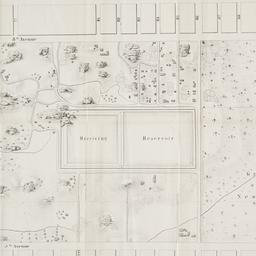
4. Map of the lands included in the Central Park
Viele, Egbert L. 1825-1902
maps
- Name: Viele, Egbert L. 1825-1902
- Published: s.n.]: New York. 1856
- Format: maps
- Online: click here for full-text
- Catalog Record: check availability
5. Topographical map of the City of New York showing original water courses and made land
Viele, Egbert L. 1825-1902
maps
- Name: Viele, Egbert L. 1825-1902
- Published: Ferd. Mayer & Co. lith: New York. c1865
- Format: maps
- Catalog Record: check availability