Search Results Header
Search Results
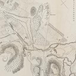
1. Map of Harlem Heights and plain, 1814
maps
- Published: [publisher not identified]: Place of publication not identified. [1856?]
- Format: maps
- Catalog Record: check availability
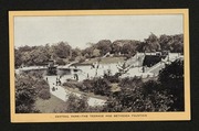
2. Singer souvenirs of New York City, uptown
Singer Sewing Machine Company
books
- Name: Singer Sewing Machine Company
- Published: s.n: New York?. 1904]
- Format: books
- Online: click here for full-text
- Catalog Record: check availability