Search Results Header
Search Results
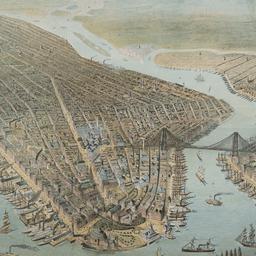
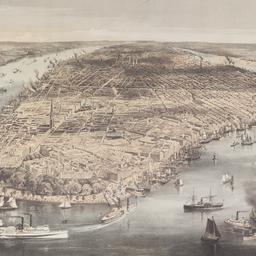
1. [Bird's-eye view of New York ]
ephemera
- Published: s.n: New York?. 1880?]
- Format: ephemera
- Catalog Record: check availability
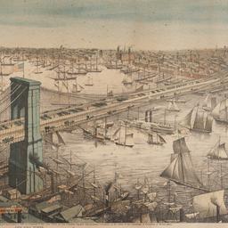
2. Bird's-eye view of the Great Suspension Bridge connecting the cities of New York and Brooklyn from New York looking south-east
Franklin Square Lithographic Company
ephemera
- Name: Franklin Square Lithographic Company
- Published: Franklin Square Lithographic Co: New York. c1883
- Format: ephemera
- Catalog Record: check availability
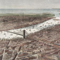
3. Bird's-eye view of the southern end of New York and Brooklyn, showing the projected suspension-bridge over the East River, from the western terminus in Printing-House Square, New York
Davis, Theodore R
maps
- Name: Davis, Theodore R
- Published: New York. 1870]
- Format: maps
- Online: click here for full-text
- Catalog Record: check availability
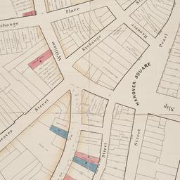
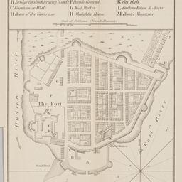
4. [Broad Street to Water Street south of Wall Street]
maps
- Published: s.n: New York?. 18--?]
- Format: maps
- Online: click here for full-text
- Catalog Record: check availability
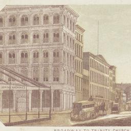
5. Broadway to Trinity Church
ephemera
- Published: s.n: New York. 18--?]
- Format: ephemera
- Catalog Record: check availability
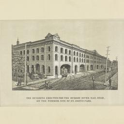
6. The building erected for the Hudson River Rail Road on the former site of St. John's Park
ephemera
- Published: E. Jones: New York. 1869]
- Format: ephemera
- Catalog Record: check availability
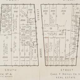
7. [Cadastral map of the area bound by South Street and Front Street between Whitehall Street and Broad Street]
maps
- Published: Chas. F. Noyes Co: New York. 1931?]
- Format: maps
- Online: click here for full-text
- Catalog Record: check availability
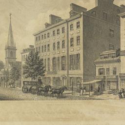
8. City Hotel, Trinity & Grace Churches Broadway
Dick, Archibald L., approximately 1805-approximately 1855
ephemera
- Name: Dick, Archibald L., approximately 1805-approximately 1855
- Published: Peabody & Co: New York. 1831
- Format: ephemera
- Catalog Record: check availability
9. City of Manhattan or New York
Bellin, Jacques Nicolas, 1703-1772
maps
- Name: Bellin, Jacques Nicolas, 1703-1772
- Published: Common Council: New York. 1861]
- Format: maps
- Online: click here for full-text
- Catalog Record: check availability
10. City of New York
Parsons, Charles, 1821-1910
maps
- Name: Parsons, Charles, 1821-1910
- Published: N. Currier: New York. 1856
- Format: maps
- Online: click here for full-text
- Catalog Record: check availability
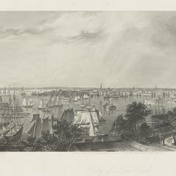
11. City of New York from Brooklyn Heights
Hall, George R., 1818-
ephemera
- Name: Hall, George R., 1818-
- Published: D. Appleton & Co: New York. c.1872
- Format: ephemera
- Catalog Record: check availability
13. First Methodist in New York City
Falconer, John Mackie, 1820-1903
ephemera
- Name: Falconer, John Mackie, 1820-1903
- Published: s.n.]: New York?. 1849
- Format: ephemera
- Catalog Record: check availability
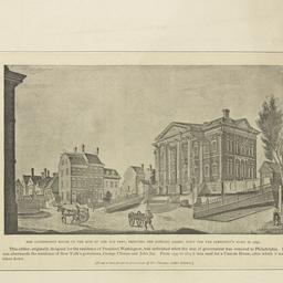
14. The government house on the site of the old fort, fronting the Bowling Green, built for the President's home in 1790
ephemera
- Published: s.n: New York?. 18--?]
- Format: ephemera
- Catalog Record: check availability

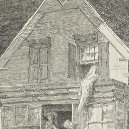
15. [Interior view of Walton House]
ephemera
- Published: s.n: New York?. 18--?]
- Format: ephemera
- Catalog Record: check availability
16. Map & plan of the proposed continuation of the widening & extension of William Street : from Maiden Lane to Chatham Street & the new line of said strt. as adopted between Wall St. & Maiden Lane, showing the situation of the property advertised by John R. Pitkin (No. 5 Broad Strt.)
maps
- Published: [publisher not identified]: N.Y.?. [183-?
- Format: maps
- Online: click here for full-text
- Catalog Record: check availability
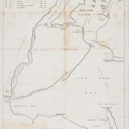
17. [Map of New York Harbor, New York Bay, and Staten Island]
maps
- Published: s.n: New York?. 18--?]
- Format: maps
- Online: click here for full-text
- Catalog Record: check availability
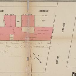
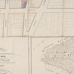
18. [Map of the area in Lower Manhattan bound by Pine Street, South Street, Wall Street and Front Street]
maps
- Published: s.n: New York?. 1895?]
- Format: maps
- Online: click here for full-text
- Catalog Record: check availability
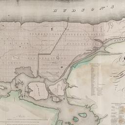
19. Map of the city and county of New York : with the adjacent country
Burr, David H., 1803-1875
maps
- Name: Burr, David H., 1803-1875
- Published: s.n: New York. 1829]
- Format: maps
- Online: click here for full-text
- Catalog Record: check availability
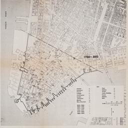
20. [Maps of land use in Lower Manhattan from 1609-1900]
maps
- Published: s.n: New York?. 19--]
- Format: maps
- Online: click here for full-text
- Catalog Record: check availability
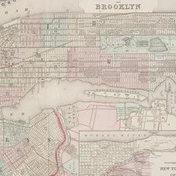
21. New York and Brooklyn
maps
- Published: s.n.]: S.l. c1867
- Format: maps
- Online: click here for full-text
- Catalog Record: check availability
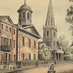
22. New York City, 1820 Broadway showing Trinity Church and Grace Church chapel
Strickland, William, 1787-1854
ephemera
- Name: Strickland, William, 1787-1854
- Published: s.n: New York?. 182-?]
- Format: ephemera
- Catalog Record: check availability
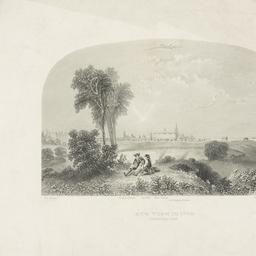
23. New York in 1768 south east view
Canot, Pierre Charles, 1710-1777
ephemera
- Name: Canot, Pierre Charles, 1710-1777
- Published: s.n: S.l. 18--?]
- Format: ephemera
- Catalog Record: check availability
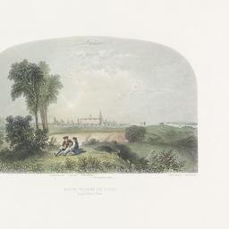
24. New York in 1776 south east view
Canot, Pierre Charles, 1710-1777
ephemera
- Name: Canot, Pierre Charles, 1710-1777
- Published: s.n: S.l. 18--?]
- Format: ephemera
- Catalog Record: check availability