Search Results Header
Search Results

121. Miniature atlas of the borough of the Bronx complete in two volumes
E. Belcher Hyde (Firm)
maps
- Name: E. Belcher Hyde (Firm)
- Published: E. Belcher Hyde: Brooklyn. 1912
- Format: maps
- Online: click here for full-text
- Catalog Record: check availability
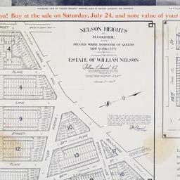
122. Nelson Heights at Woodside in the Second Ward, borough of Queens, New York City
maps
- Published: William Kennely, Inc: New York. [1926]
- Format: maps
- Online: click here for full-text
- Catalog Record: check availability
123. A new map of America from the latest observations
Senex, John, -1740
maps
- Name: Senex, John, -1740
- Published: s.n: S.l. 19--?]
- Format: maps
- Online: click here for full-text
- Catalog Record: check availability
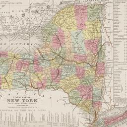
124. A new map of New York : with its canals, roads & distances
Thomas, Cowperthwait & Co
maps
- Name: Thomas, Cowperthwait & Co
- Published: Thomas, Cowperthwait & Co: Philadelphia. 1850
- Format: maps
- Online: click here for full-text
- Catalog Record: check availability
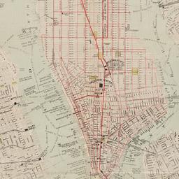
125. New map of New York City : from the latest surveys showing all the ferries and steamship docks, elevated, cable, and cross town car lines
Brooks Bank Note Co
maps
- Name: Brooks Bank Note Co
- Published: Broadway Central Hotel, Tilly Haynes, proprietor: New York. [189-?]
- Format: maps
- Online: click here for full-text
- Catalog Record: check availability

126. A new map of the City of New York : comprising all the late improvements, compiled and corrected from authentic documents, designed to accompany the Description of New York
Marks, Samuel
maps
- Name: Marks, Samuel
- Published: S. Marks: New York. 1827
- Format: maps
- Online: click here for full-text
- Catalog Record: check availability
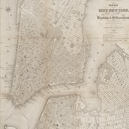
127. New map of the city of New York with part of Brooklyn & Williamsburg
Smith, J. Calvin
maps
- Name: Smith, J. Calvin
- Published: Published by H.S. Tanner map selr., 237 Broadway: New York. 1846
- Format: maps
- Online: click here for full-text
- Catalog Record: check availability
128. New York
maps
- Published: Letts, Son & Co: London. [1885?]
- Format: maps
- Online: click here for full-text
- Catalog Record: check availability
129. New York
maps
- Published: s.n: New York. between 1864 and 1869]
- Format: maps
- Online: click here for full-text
- Catalog Record: check availability
130. New York
maps
- Published: Letts, Son & Co: London. [1885?]
- Format: maps
- Online: click here for full-text
- Catalog Record: check availability
131. New York and Brooklyn
maps
- Published: s.n.]: S.l. c1867
- Format: maps
- Online: click here for full-text
- Catalog Record: check availability
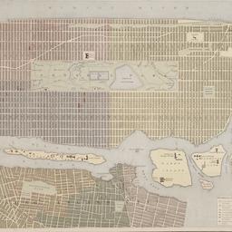
132. New York and its surroundings : map of the metropolis from the Battery to One Hundred and Eighth Street, and parts of Brooklyn, Williamsburg, Greenpoint, Jersey City, and Hoboken
maps
- Published: Harper's Weekly: New York?. 1873
- Format: maps
- Catalog Record: check availability

133. New York canals : Champlain Canal, Erie Canal, Oswego Canal, Cayuga and Seneca Canal
U.S. Lake Survey
maps
- Name: U.S. Lake Survey
- Published: U.S. Lake Survey: Detroit, Mich. [1948]
- Format: maps
- Online: click here for full-text
- Catalog Record: check availability
134. New York City
Asher & Adams
maps
- Name: Asher & Adams
- Published: Asher & Adams: New York. 1871]
- Format: maps
- Online: click here for full-text
- Catalog Record: check availability

135. New York City
maps
- Published: s.n: New York?. 1896?]
- Format: maps
- Online: click here for full-text
- Catalog Record: check availability

136. New York, city and vicinity
maps
- Published: s.n: S.l. 1889?]
- Format: maps
- Online: click here for full-text
- Catalog Record: check availability
137. New York, city (lower part)
maps
- Published: s.n: S.l. 1889?]
- Format: maps
- Online: click here for full-text
- Catalog Record: check availability
138. New York city map
Phelps, Humphrey, active 19th century
maps
- Name: Phelps, Humphrey, active 19th century
- Published: H. Phelps: New York. c1857
- Format: maps
- Online: click here for full-text
- Catalog Record: check availability

139. New York State barge canal system
U.S. Lake Survey
maps
- Name: U.S. Lake Survey
- Published: Dept. of the Army, Lake Survey District, Corps of Engineers: Detroit. 1948
- Format: maps
- Online: click here for full-text
- Catalog Record: check availability
140. New Yorke, 1695
Miller, John, 1666-1724
maps
- Name: Miller, John, 1666-1724
- Published: Lith. G. Hayward: New York. [1852]
- Format: maps
- Online: click here for full-text
- Catalog Record: check availability
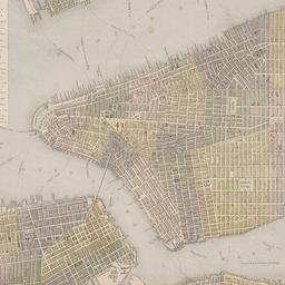
141. New-York, April 1852 drawn on an enlarged scale from map of district burnt by great fire of 16th Dec. 1835, as published in the Journal of Commerce Dec. 18th, 1835
maps
- Published: s.n: New York?. 1852?]
- Format: maps
- Online: click here for full-text
- Catalog Record: check availability
142. New-York city & county map : with vicinity entire, Brooklyn, Williamsburgh, Jersey City &c. in the 79th year of the independence of the United States
Magnus, Charles
maps
- Name: Magnus, Charles
- Published: Charles Magnus: New York. [1855?]
- Format: maps
- Online: click here for full-text
- Catalog Record: check availability
143. New-York City, County and vicinity
Dripps, M
maps
- Name: Dripps, M
- Published: s.n: New York?. 1866]
- Format: maps
- Online: click here for full-text
- Catalog Record: check availability
![The Nicolls [sic] map, 1664...](https://triclops.library.columbia.edu/iiif/2/featured/cul:d7wm37pvtw/full/!256,256/0/default.jpg)
144. The Nicolls [sic] map, 1664-1668
Nicholls, Sutton
maps
- Name: Nicholls, Sutton
- Published: Lith. by G. Hayward for D.T. Valentine's Manual: N.Y., N.Y. 1863
- Format: maps
- Online: click here for full-text
- Catalog Record: check availability