Search Results Header
Search Results
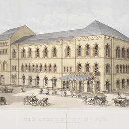
1. The Academy of Music Montague Street, Brooklyn
ephemera
- Published: Brooklyn, I. Van Anden. 1863]
- Format: ephemera
- Catalog Record: check availability
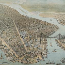
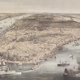
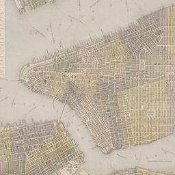
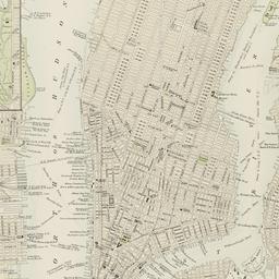
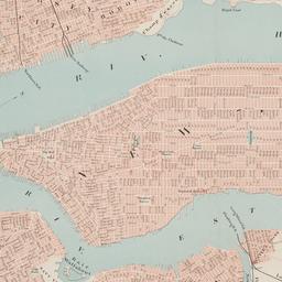
2. [Bird's-eye view of New York ]
ephemera
- Published: s.n: New York?. 1880?]
- Format: ephemera
- Catalog Record: check availability
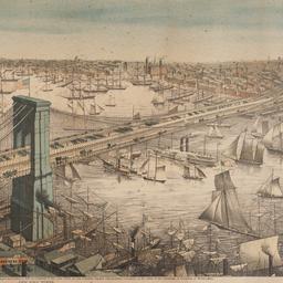
3. Bird's-eye view of the Great Suspension Bridge connecting the cities of New York and Brooklyn from New York looking south-east
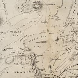
Franklin Square Lithographic Company
ephemera
- Name: Franklin Square Lithographic Company
- Published: Franklin Square Lithographic Co: New York. c1883
- Format: ephemera
- Catalog Record: check availability
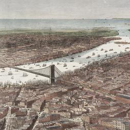
4. Bird's-eye view of the southern end of New York and Brooklyn, showing the projected suspension-bridge over the East River, from the western terminus in Printing-House Square, New York
Davis, Theodore R
maps
- Name: Davis, Theodore R
- Published: New York. 1870]
- Format: maps
- Online: click here for full-text
- Catalog Record: check availability
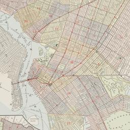
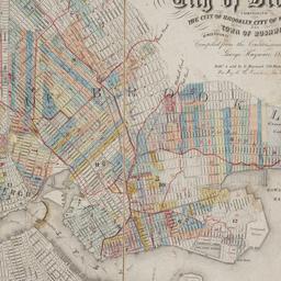
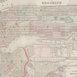
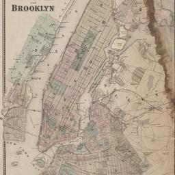
5. Brooklyn
maps
- Published: E.F. Fisk: New York. [1890?]
- Format: maps
- Online: click here for full-text
- Catalog Record: check availability
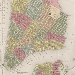
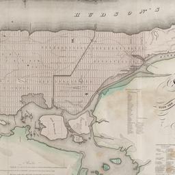
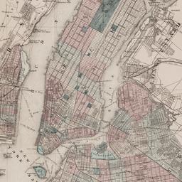
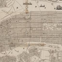
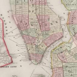
6. City of New York
Parsons, Charles, 1821-1910
maps
- Name: Parsons, Charles, 1821-1910
- Published: N. Currier: New York. 1856
- Format: maps
- Online: click here for full-text
- Catalog Record: check availability

7. The city of New York
Williams, J. W., active 1879
maps
- Name: Williams, J. W., active 1879
- Published: New York. ©1879
- Format: maps
- Online: click here for full-text
- Catalog Record: check availability
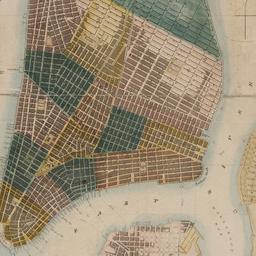
8. City of New York
Thomas, Cowperthwait & Co
maps
- Name: Thomas, Cowperthwait & Co
- Published: s.n.]: Philadelphia, Pa.?. 1850
- Format: maps
- Online: click here for full-text
- Catalog Record: check availability
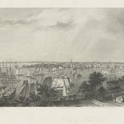
9. City of New York from Brooklyn Heights
Hall, George R., 1818-
ephemera
- Name: Hall, George R., 1818-
- Published: D. Appleton & Co: New York. c.1872
- Format: ephemera
- Catalog Record: check availability
10. City of New-York
Burr, David H., 1803-1875
maps
- Name: Burr, David H., 1803-1875
- Published: Republished by W.P. Stone: Ithaca, N.Y. 1838
- Format: maps
- Online: click here for full-text
- Catalog Record: check availability

11. [Collection of materials about the improvement of the beachfront area on Coney Island]
ephemera
- Published: New York?. 1932-1937]
- Format: ephemera
- Online: click here for full-text
- Catalog Record: check availability
12. Colton's map of the cities of New York, Brooklyn, Jersey City, Hoboken, etc
maps
- Published: G.W. & C.B. Colton & Co: New York. c1886
- Format: maps
- Online: click here for full-text
- Catalog Record: check availability
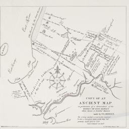
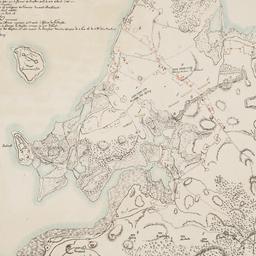
13. Copy of an ancient map in possession of a descendant of the Hannes or Han Bergen : whose house is located thereon
Bergen, Teunis G., 1806-1881
maps
- Name: Bergen, Teunis G., 1806-1881
- Published: Henry McCloskey?: N.Y.?. 1864]
- Format: maps
- Online: click here for full-text
- Catalog Record: check availability
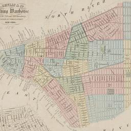
14. D. Devlin & Co., clothing warehouse
D. Devlin & Co
maps
- Name: D. Devlin & Co
- Published: James Mowlem & Co: N[ew] Y[ork]. [185-]
- Format: maps
- Online: click here for full-text
- Catalog Record: check availability
15. Green Wood Cemetery
maps
- Published: s.n.]: S.l. 1869
- Format: maps
- Online: click here for full-text
- Catalog Record: check availability

16. Green-wood cemetery
maps
- Published: s.n.]: S.l. 1890
- Format: maps
- Online: click here for full-text
- Catalog Record: check availability

17. Green-Wood Cemetery
maps
- Published: s.n.]: New York?. 1887
- Format: maps
- Online: click here for full-text
- Catalog Record: check availability
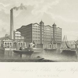
18. Havemeyers & Elder Sugar Refinery, New York
ephemera
- Published: Atlantic Publishing & Engraving Company: New York. [18--?]
- Format: ephemera
- Catalog Record: check availability
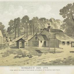
19. Howard's Inn, 1776 from which the guides of the flanking detachment of the British were taken
ephemera
- Published: A. Brown: New York. [between 1866 and 1874]
- Format: ephemera
- Catalog Record: check availability
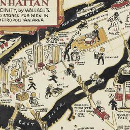
20. A man's map of Manhattan and vicinity by Wallach's
Voorhies, Stephen J
maps
- Name: Voorhies, Stephen J
- Format: maps
- Catalog Record: check availability
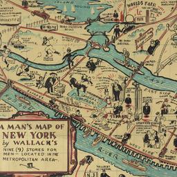
21. A man's map of New York by Wallach's
Voorhies, Stephen J
maps
- Name: Voorhies, Stephen J
- Format: maps
- Catalog Record: check availability
22. A man's map of New York by Wallach's
Voorhies, Stephen J
maps
- Name: Voorhies, Stephen J
- Format: maps
- Catalog Record: check availability
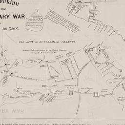
23. Map of Brooklyn at the time of the Revolutionary War
Johnson, Jeremiah, 1768-1852
maps
- Name: Johnson, Jeremiah, 1768-1852
- Published: George Hayward: N[ew] Y[ork]. [1858]
- Format: maps
- Online: click here for full-text
- Catalog Record: check availability
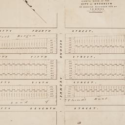
24. Map of land of Theodorus Bergen west of Third Avenue in the Eighth Ward of the city of Brooklyn : as surveyed December 1853 by T.G. Bergen
Bergen, Teunis G., 1806-1881
maps
- Name: Bergen, Teunis G., 1806-1881
- Format: maps
- Catalog Record: check availability
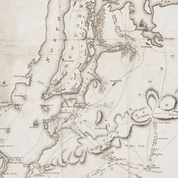
25. [Map of Manhattan, Brooklyn, Staten Island, Long Island, and New Jersey with references to the Battle on Long Island]
maps
- Published: s.n: New York?. 18--?]
- Format: maps
- Online: click here for full-text
- Catalog Record: check availability

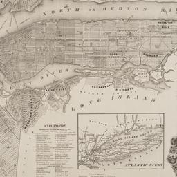
26. Map of New York and vicinity
Dripps, M
maps
- Name: Dripps, M
- Published: M. Dripps: N[ew] Y[ork]. c1865
- Format: maps
- Online: click here for full-text
- Catalog Record: check availability
27. Map of New York City
maps
- Published: Hunt & Eaton: New York?. c1891
- Format: maps
- Online: click here for full-text
- Catalog Record: check availability
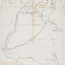
28. [Map of New York Harbor, New York Bay, and Staten Island]
maps
- Published: s.n: New York?. 18--?]
- Format: maps
- Online: click here for full-text
- Catalog Record: check availability
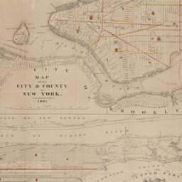
29. Map of the city & county of New York
Hayward, George, approximately 1800-
maps
- Name: Hayward, George, approximately 1800-
- Published: Engraved for D.T. Valentine's manual for 1862, by Geo. Hayward: New York (N.Y.). [1861]
- Format: maps
- Online: click here for full-text
- Catalog Record: check availability
30. Map of the city and county of New York : with the adjacent country
Burr, David H., 1803-1875
maps
- Name: Burr, David H., 1803-1875
- Published: s.n: New York. 1829]
- Format: maps
- Online: click here for full-text
- Catalog Record: check availability

31. Map of the City of New York
W.C. Rogers & Co
maps
- Name: W.C. Rogers & Co
- Published: s.n.]: New York. 1868
- Format: maps
- Online: click here for full-text
- Catalog Record: check availability
32. Map of the consolidated City of Brooklyn : comprising the City of Brooklyn, City of Williamsburgh and Town of Bushwick, Kings County, Long Island
Hayward, George, approximately 1800-
maps
- Name: Hayward, George, approximately 1800-
- Published: G. Hayward: New York. 1854
- Format: maps
- Online: click here for full-text
- Catalog Record: check availability
33. New map of New York City : from the latest surveys showing all the ferries and steamship docks, elevated, cable, and cross town car lines
Brooks Bank Note Co
maps
- Name: Brooks Bank Note Co
- Published: Broadway Central Hotel, Tilly Haynes, proprietor: New York. [189-?]
- Format: maps
- Online: click here for full-text
- Catalog Record: check availability
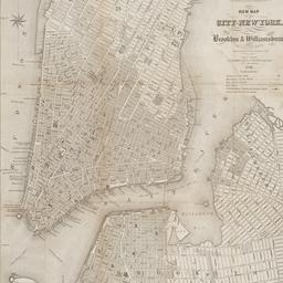
34. New map of the city of New York with part of Brooklyn & Williamsburg
Smith, J. Calvin
maps
- Name: Smith, J. Calvin
- Published: Published by H.S. Tanner map selr., 237 Broadway: New York. 1846
- Format: maps
- Online: click here for full-text
- Catalog Record: check availability
35. New York
maps
- Published: Letts, Son & Co: London. [1885?]
- Format: maps
- Online: click here for full-text
- Catalog Record: check availability
36. New York and Brooklyn
maps
- Published: s.n.]: S.l. c1867
- Format: maps
- Online: click here for full-text
- Catalog Record: check availability
37. New York and its surroundings : map of the metropolis from the Battery to One Hundred and Eighth Street, and parts of Brooklyn, Williamsburg, Greenpoint, Jersey City, and Hoboken
maps
- Published: Harper's Weekly: New York?. 1873
- Format: maps
- Catalog Record: check availability
38. New York City
Asher & Adams
maps
- Name: Asher & Adams
- Published: Asher & Adams: New York. 1871]
- Format: maps
- Online: click here for full-text
- Catalog Record: check availability
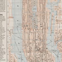
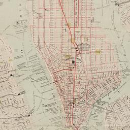
39. New York, city (lower part)
maps
- Published: s.n: S.l. 1889?]
- Format: maps
- Online: click here for full-text
- Catalog Record: check availability
40. New York city map
Phelps, Humphrey, active 19th century
maps
- Name: Phelps, Humphrey, active 19th century
- Published: H. Phelps: New York. c1857
- Format: maps
- Online: click here for full-text
- Catalog Record: check availability
41. New York from Brooklyn Heights : 6th August 1778
Smith, Sidney Lawton, 1845-1929
ephemera
- Name: Smith, Sidney Lawton, 1845-1929
- Published: s.n: New York ?. 1922]
- Format: ephemera
- Catalog Record: check availability
42. New-York city & county map : with vicinity entire, Brooklyn, Williamsburgh, Jersey City &c. in the 79th year of the independence of the United States
Magnus, Charles
maps
- Name: Magnus, Charles
- Published: Charles Magnus: New York. [1855?]
- Format: maps
- Online: click here for full-text
- Catalog Record: check availability
43. New-York City, County and vicinity
Dripps, M
maps
- Name: Dripps, M
- Published: s.n: New York?. 1866]
- Format: maps
- Online: click here for full-text
- Catalog Record: check availability

44. Outline map of Brooklyn, N.Y., showing present and original shoreline and marshy tracts
maps
- Published: s.n: New York?. 189-?]
- Format: maps
- Online: click here for full-text
- Catalog Record: check availability
45. Plan de New-York (Etats-Unis)
maps
- Published: Becquet: Paris. [188-?]
- Format: maps
- Online: click here for full-text
- Catalog Record: check availability
46. Plan des redoutes et des lignes que les ennemis avoient auprès de Brookland, de ceux de Redhook, et l"isle de Gouveurner
Riepe, G
maps
- Name: Riepe, G
- Published: s.n: S.l. 187-?]
- Format: maps
- Online: click here for full-text
- Catalog Record: check availability
47. Plan of New York and Brooklyn
maps
- Published: s.n: S.l. 186-?]
- Format: maps
- Online: click here for full-text
- Catalog Record: check availability
48. Plan of New York &c
Mitchell, S. Augustus, Jr
maps
- Name: Mitchell, S. Augustus, Jr
- Published: S. Augustus Mitchell, Jr: Philadelphia. c1866
- Format: maps
- Online: click here for full-text
- Catalog Record: check availability
49. A Plan of New York Island, Part of Long Island, &c. shewing the Position of the American and British Armies, before, at, and after the Engagement of the Heights, August 27th, 1776
Lewis, Samuel, 1753 or 1754-1822
maps
- Name: Lewis, Samuel, 1753 or 1754-1822
- Published: Richard Phillips: London?. 1806
- Format: maps
- Online: click here for full-text
- Catalog Record: check availability
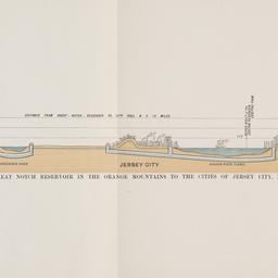
50. Profile of pipe lines and tunnels from Great Notch Reservoir in the Orange Mountains to the cities of Jersey City, New York, and Brooklyn
ephemera
- Published: s.n: New York?. 19--?]
- Format: ephemera
- Catalog Record: check availability