Search Results Header
Search Results
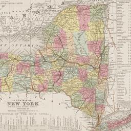
97. Map of the State of New York : with the latest improvements showing all the canals, railroads, &c
maps
- Published: J. Disturnell: New York. 1836
- Format: maps
- Online: click here for full-text
- Catalog Record: check availability
98. [Map showing area bounded by Tompkins Street and 3rd Avenue between 23rd and 9th Streets]
maps
- Published: s.n: New York?. 18--?]
- Format: maps
- Online: click here for full-text
- Catalog Record: check availability
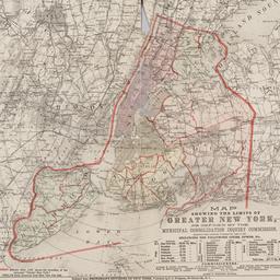
99. Map showing the limits of greater New York, as defined by the Municipal Consolidation Inquiry Commisssion appointed under the authority of Chapter 311, Laws of 1890 including the following cities, towns, etc
maps
- Published: E.C. Bridgman: New York?. 1890?]
- Format: maps
- Online: click here for full-text
- Catalog Record: check availability
100. [Maps of land use in Lower Manhattan from 1609-1900]
maps
- Published: s.n: New York?. 19--]
- Format: maps
- Online: click here for full-text
- Catalog Record: check availability
![[Maps of Manhattan]](https://archive.org/services/img/ldpd_11290413_000)
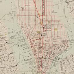
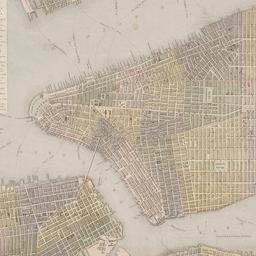
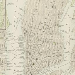
101. [Maps of Manhattan]
maps
- Published: s.n: New York?. ca. 1890]
- Format: maps
- Online: click here for full-text
- Catalog Record: check availability
102. Middle part of Long Island Sound
United States Coast Survey
maps
- Name: United States Coast Survey
- Published: U.S.C. & G.S: Washington, D.C. 1855
- Format: maps
- Online: click here for full-text
- Catalog Record: check availability

103. Miniature atlas of the borough of Manhattan : in one volume
Hyde, E. Belcher
maps
- Name: Hyde, E. Belcher
- Published: Hyde: Brooklyn. 1912
- Format: maps
- Online: click here for full-text
- Catalog Record: check availability
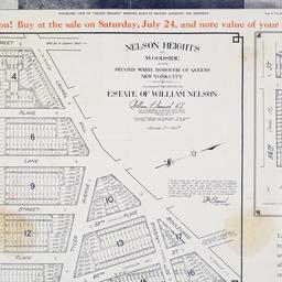
104. Nelson Heights at Woodside in the Second Ward, borough of Queens, New York City
maps
- Published: William Kennely, Inc: New York. [1926]
- Format: maps
- Online: click here for full-text
- Catalog Record: check availability
105. A new map of America from the latest observations
Senex, John, -1740
maps
- Name: Senex, John, -1740
- Published: s.n: S.l. 19--?]
- Format: maps
- Online: click here for full-text
- Catalog Record: check availability
106. A new map of New York : with its canals, roads & distances
Thomas, Cowperthwait & Co
maps
- Name: Thomas, Cowperthwait & Co
- Published: Thomas, Cowperthwait & Co: Philadelphia. 1850
- Format: maps
- Online: click here for full-text
- Catalog Record: check availability
107. New map of New York City : from the latest surveys showing all the ferries and steamship docks, elevated, cable, and cross town car lines
Brooks Bank Note Co
maps
- Name: Brooks Bank Note Co
- Published: Broadway Central Hotel, Tilly Haynes, proprietor: New York. [189-?]
- Format: maps
- Online: click here for full-text
- Catalog Record: check availability
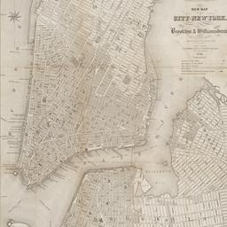
108. New map of the city of New York with part of Brooklyn & Williamsburg
Smith, J. Calvin
maps
- Name: Smith, J. Calvin
- Published: Published by H.S. Tanner map selr., 237 Broadway: New York. 1846
- Format: maps
- Online: click here for full-text
- Catalog Record: check availability
109. New York
maps
- Published: Letts, Son & Co: London. [1885?]
- Format: maps
- Online: click here for full-text
- Catalog Record: check availability
110. New York
maps
- Published: s.n: New York. between 1864 and 1869]
- Format: maps
- Online: click here for full-text
- Catalog Record: check availability
111. New York
maps
- Published: Letts, Son & Co: London. [1885?]
- Format: maps
- Online: click here for full-text
- Catalog Record: check availability
112. New York and Brooklyn
maps
- Published: s.n.]: S.l. c1867
- Format: maps
- Online: click here for full-text
- Catalog Record: check availability
113. New York and its surroundings : map of the metropolis from the Battery to One Hundred and Eighth Street, and parts of Brooklyn, Williamsburg, Greenpoint, Jersey City, and Hoboken
maps
- Published: Harper's Weekly: New York?. 1873
- Format: maps
- Catalog Record: check availability
114. New York City
Asher & Adams
maps
- Name: Asher & Adams
- Published: Asher & Adams: New York. 1871]
- Format: maps
- Online: click here for full-text
- Catalog Record: check availability

115. New York, city and vicinity
maps
- Published: s.n: S.l. 1889?]
- Format: maps
- Online: click here for full-text
- Catalog Record: check availability
116. New York, city (lower part)
maps
- Published: s.n: S.l. 1889?]
- Format: maps
- Online: click here for full-text
- Catalog Record: check availability
117. New York city map
Phelps, Humphrey, active 19th century
maps
- Name: Phelps, Humphrey, active 19th century
- Published: H. Phelps: New York. c1857
- Format: maps
- Online: click here for full-text
- Catalog Record: check availability
118. New Yorke, 1695
Miller, John, 1666-1724
maps
- Name: Miller, John, 1666-1724
- Published: Lith. G. Hayward: New York. [1852]
- Format: maps
- Online: click here for full-text
- Catalog Record: check availability
119. New-York city & county map : with vicinity entire, Brooklyn, Williamsburgh, Jersey City &c. in the 79th year of the independence of the United States
Magnus, Charles
maps
- Name: Magnus, Charles
- Published: Charles Magnus: New York. [1855?]
- Format: maps
- Online: click here for full-text
- Catalog Record: check availability
![The Nicolls [sic] map, 1664...](https://triclops.library.columbia.edu/iiif/2/featured/cul:d7wm37pvtw/full/!256,256/0/default.jpg)
120. The Nicolls [sic] map, 1664-1668
Nicholls, Sutton
maps
- Name: Nicholls, Sutton
- Published: Lith. by G. Hayward for D.T. Valentine's Manual: N.Y., N.Y. 1863
- Format: maps
- Online: click here for full-text
- Catalog Record: check availability
Search Other Sources for: "Architecture"
Try your search in one of these related resources. (Search results will display in a new window.)
-
Avery Index to Architectural Periodicals
A comprehensive listing of journal articles published worldwide on architecture and design, archaeology, city planning, interior design, landscape architecture, and historic preservation. -
Brooklyn Historical Society Photography Collection
Search for individual photographs. Approximately 5,000 of our images are currently available online, but more images are added regularly. -
Brooklyn Public Library: Historic Brooklyn Photographs
Selection of more than ten thousand historic photographs from the Brooklyn Collection. -
CLIO: Columbia Libraries Catalog
Search for books, articles, journals, online resources and more. -
DLC: Columbia Libraries Digital Collections
A gateway to digital projects and online exhibitions that have been published on the web by Columbia University Libraries/Information Services (CUL/IS). -
Museum of the City of New York
Over 150,000 images and objects from the collections of the Museum of the City of New York.
Note: to come. -
New York Historical Society
Digital images from the library and museum collections. -
NYPL Digital Collections
Provides free and open access to over 800,000 images digitized from the The New York Public Library's vast collections.